Alae geodata
Alae (Northern Mindanao) is a populated place; located in Philippines in Asia/Manila (GMT+8) time zone. With population of 5,121 people, there are 1251 cities with bigger population in this country. Compared to other cities in Philippines, 79.3% of cities are located further ↑North; 84.8% of cities are located further ←West and 95.1% of cities have lower elevation than Alae. Note1
Administrative division(s):
- Level 1: Northern Mindanao
- Level 2: Province of Bukidnon
- Level 3: Manolo Fortich


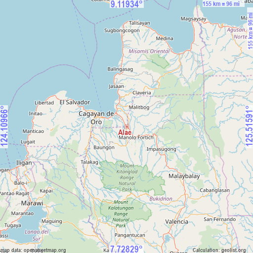
Alae GPS coordinates[2]
8° 25' 27.984" North, 124° 48' 46.008" East
| Map corner | latitude | longitude |
|---|---|---|
| Upper-left | 9.11934°, | 124.10966° |
| Center: | 8.42444°, | 124.81278° |
| Lower-right: | 7.72829°, | 125.51591° |
| Map W x H: | 154.7×154.7 km | = 96.1×96.1mi |
| max Lat: | 20.78733° ⇑79.3% North |
| Alae: | 8.42444° |
| min Lat: | ⇓20.7% South 4.65442° |
| min Long | Alae | max Long |
| 117.04868° | 124.81278° | 126.58417° |
| W 84.8%⇐ | ⇒15.2% E |
Elevation
Elevation of Alae is 420 m = 1378 ft, and this is 332.1 m = 1090 ft above average elevation for this country.
| Max E: |
2262 m = 7421 ft | 4.9% |
| Alae | 420 m 1378 ft | |
| Avg. | 87.9 m = 288 ft | |
Min E: |
-2 m = -7 ft | 95.1% |
See also: Philippines elevation on elevation.city.
Geographical zone
Alae is located in North Torrid zone (between Equator and Tropic of Cancer). Distance of Equator is 936.7 km =582 mi to South.| Distance of | km | miles | from Alae |
|---|---|---|---|
| North Pole | 9070.4 | 5636.1 | to North |
| Arctic Circle | 6464.5 | 4016.9 | to North |
| Tropic Cancer | 1669.2 | 1037.2 | to North |
| Equator | 936.7 | 582 | to South |


Nearby cities:
15 places around Alae: (largest is in red/bold)
• Agusan
11.1 km =6.9 mi,  311°
311°
• Bugo
11 km =6.8 mi,  327°
327°
• Dalirig
11.1 km =6.9 mi,  118°
118°
• Damilag
7.8 km =4.8 mi,  180°
180°
• Kimaya
15.9 km =9.9 mi,  10°
10°
• Libona
12.8 km =8 mi,  221°
221°
• Malitbog
14.4 km =8.9 mi,  32°
32°
• Maluko
16.5 km =10.3 mi,  109°
109°
• Mambatangan
2.5 km =1.6 mi,  66°
66°
• Manolo Fortich
8.3 km =5.2 mi,  136°
136°
• San Martin
15.9 km =9.9 mi,  343°
343°
• Sankanan
13.1 km =8.1 mi,  157°
157°
• Santa Ana
10.8 km =6.7 mi, 342°
• Santa Fe
9.8 km =6.1 mi,  201°
201°
• Tagoloan
14.3 km =8.9 mi, 333°
Sources, notices
• [Note1] Compared only with cities in Philippines existing in our database
• [Src1] Map data: © OpenStreetMap contributors (CC-BY-SA)
• [Src2] Other city data from geonames.org with taken over terms of usage.
• [Src3] Geographical zone / Annual Mean Temperature by Robert A. Rohde @ Wikipedia
