Imus geodata
Imus (Calabarzon) is a seat of a third-order administrative division; located in Philippines in Asia/Manila (GMT+8) time zone. With population of 216,099 people, there are 50 cities with bigger population in this country. Compared to other cities in Philippines, 73.8% of cities are located further ↓South; 78.3% of cities are located further →East and 76.6% of cities have higher elevation than Imus. Note1


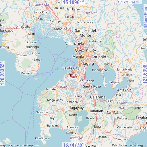
Imus GPS coordinates[2]
14° 25' 46.992" North, 120° 56' 12.012" East
| Map corner | latitude | longitude |
|---|---|---|
| Upper-left | 15.10961°, | 120.23355° |
| Center: | 14.42972°, | 120.93667° |
| Lower-right: | 13.74775°, | 121.6398° |
| Map W x H: | 151.4×151.4 km | = 94.1×94.1mi |
| max Lat: | 20.78733° ⇑26.2% North |
| Imus: | 14.42972° |
| min Lat: | ⇓73.8% South 4.65442° |
| min Long | Imus | max Long |
| 117.04868° | 120.93667° | 126.58417° |
| W 21.7%⇐ | ⇒78.3% E |
Elevation
Elevation of Imus is 10 m = 33 ft, and this is 77.9 m = 256 ft below average elevation for this country.
| Max E: |
2262 m = 7421 ft | 76.6% |
| Avg. | 87.9 m = 288 ft | |
| Imus | 10 m = 33 ft | |
Min E: |
-2 m = -7 ft | 23.4% |
See also: Imus elevation on elevation.city.
Geographical zone
Imus is located in North Torrid zone (between Equator and Tropic of Cancer). Distance of this Northern Tropic circle is 1001.5 km =622.3 mi to North.| Distance of | km | miles | from Imus |
|---|---|---|---|
| North Pole | 8402.6 | 5221.1 | to North |
| Arctic Circle | 5796.7 | 3601.9 | to North |
| Tropic Cancer | 1001.5 | 622.3 | to North |
| Equator | 1604.4 | 996.9 | to South |


Nearby cities:
15 places around Imus: (largest is in red/bold)
• Bacoor
3.3 km =2.1 mi,  3°
3°
• Cavite City
7.3 km =4.5 mi,  325°
325°
• Dasmariñas
11.2 km =7 mi,  180°
180°
• General Trias
7.6 km =4.7 mi,  231°
231°
• Kanluran
9.4 km =5.8 mi,  261°
261°
• Kawit
4.1 km =2.5 mi,  293°
293°
• Las Piñas
5.5 km =3.4 mi,  64°
64°
• Muntinlupa
12.7 km =7.9 mi,  110°
110°
• Noveleta
6.1 km =3.8 mi,  269°
269°
• Pasay
13.9 km =8.6 mi,  30°
30°
• Pasong Kawayan Primero
11.3 km =7 mi,  211°
211°
• Rosario
8.6 km =5.3 mi, 261°
• Sambayanihan People's Village
7.2 km =4.5 mi,  66°
66°
• Santa Rosa
6.2 km =3.9 mi, 266°
• Tanza
9.4 km =5.8 mi,  248°
248°
Sources, notices
• [Note1] Compared only with cities in Philippines existing in our database
• [Src1] Map data: © OpenStreetMap contributors (CC-BY-SA)
• [Src2] Other city data from geonames.org with taken over terms of usage.
• [Src3] Geographical zone / Annual Mean Temperature by Robert A. Rohde @ Wikipedia
