Las Piñas geodata
Las Piñas (Metro Manila) is a seat of a third-order administrative division; located in Philippines in Asia/Manila (GMT+8) time zone. With population of 590,000 people, there are 10 cities with bigger population in this country. Compared to other cities in Philippines, 73.9% of cities are located further ↓South; 76.7% of cities are located further →East and 59.2% of cities have higher elevation than Las Piñas. Note1
Administrative division(s):
- Level 1: Metro Manila
- Level 2: Southern Manila District
- Level 3: City of Las Piñas


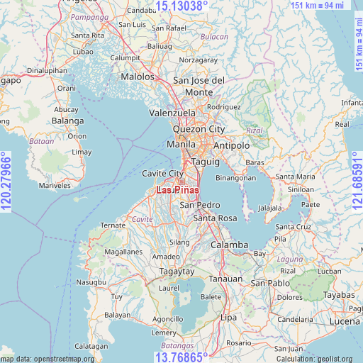
Las Piñas GPS coordinates[2]
14° 27' 2.016" North, 120° 58' 58.008" East
| Map corner | latitude | longitude |
|---|---|---|
| Upper-left | 15.13038°, | 120.27966° |
| Center: | 14.45056°, | 120.98278° |
| Lower-right: | 13.76865°, | 121.68591° |
| Map W x H: | 151.4×151.4 km | = 94.1×94.1mi |
| max Lat: | 20.78733° ⇑26.1% North |
| Las Piñas: | 14.45056° |
| min Lat: | ⇓73.9% South 4.65442° |
| min Long | Las Piñas | max Long |
| 117.04868° | 120.98278° | 126.58417° |
| W 23.3%⇐ | ⇒76.7% E |
Elevation
Elevation of Las Piñas is 17 m = 56 ft, and this is 70.9 m = 233 ft below average elevation for this country.
| Max E: |
2262 m = 7421 ft | 59.2% |
| Avg. | 87.9 m = 288 ft | |
| Las Piñas | 17 m = 56 ft | |
Min E: |
-2 m = -7 ft | 40.8% |
See also: Las Piñas elevation on elevation.city.
Geographical zone
Las Piñas is located in North Torrid zone (between Equator and Tropic of Cancer). Distance of this Northern Tropic circle is 999.2 km =620.9 mi to North.| Distance of | km | miles | from Las Piñas |
|---|---|---|---|
| North Pole | 8400.3 | 5219.7 | to North |
| Arctic Circle | 5794.4 | 3600.5 | to North |
| Tropic Cancer | 999.2 | 620.9 | to North |
| Equator | 1606.8 | 998.4 | to South |


Nearby cities:
15 places around Las Piñas: (largest is in red/bold)
• Bacoor
4.9 km =3 mi,  281°
281°
• Cavite City
9.8 km =6.1 mi,  292°
292°
• General Trias
13 km =8.1 mi,  236°
236°
• Imus
5.5 km =3.4 mi, 244°
• Kawit
8.8 km =5.5 mi,  265°
265°
• Magsaysay
13.6 km =8.5 mi,  156°
156°
• Makati City
12.3 km =7.6 mi,  25°
25°
• Muntinlupa
9.7 km =6 mi,  133°
133°
• Noveleta
11.3 km =7 mi,  257°
257°
• Pasay
9.9 km =6.2 mi,  11°
11°
• Pateros
13.8 km =8.6 mi,  44°
44°
• Sambayanihan People's Village
1.7 km =1.1 mi,  71°
71°
• San Pedro
12.3 km =7.6 mi,  145°
145°
• Santa Rosa
11.5 km =7.1 mi, 256°
• Taguig
13.2 km =8.2 mi,  51°
51°
Sources, notices
• [Note1] Compared only with cities in Philippines existing in our database
• [Src1] Map data: © OpenStreetMap contributors (CC-BY-SA)
• [Src2] Other city data from geonames.org with taken over terms of usage.
• [Src3] Geographical zone / Annual Mean Temperature by Robert A. Rohde @ Wikipedia
