Calauan geodata
Calauan (Calabarzon) is a seat of a third-order administrative division; located in Philippines in Asia/Manila (GMT+8) time zone. With population of 36,580 people, there are 234 cities with bigger population in this country. Compared to other cities in Philippines, 71.1% of cities are located further ↓South; 69.9% of cities are located further →East and 57.6% of cities have higher elevation than Calauan. Note1


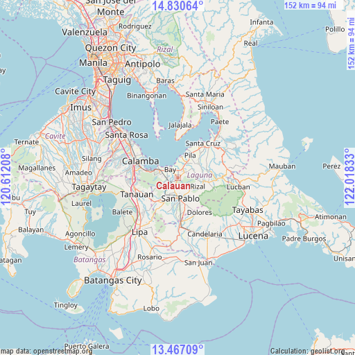
Calauan GPS coordinates[2]
14° 8' 59.604" North, 121° 18' 54.72" East
| Map corner | latitude | longitude |
|---|---|---|
| Upper-left | 14.83064°, | 120.61208° |
| Center: | 14.14989°, | 121.3152° |
| Lower-right: | 13.46709°, | 122.01833° |
| Map W x H: | 151.6×151.6 km | = 94.2×94.2mi |
| max Lat: | 20.78733° ⇑28.9% North |
| Calauan: | 14.14989° |
| min Lat: | ⇓71.1% South 4.65442° |
| min Long | Calauan | max Long |
| 117.04868° | 121.3152° | 126.58417° |
| W 30.1%⇐ | ⇒69.9% E |
Elevation
Elevation of Calauan is 18 m = 59 ft, and this is 69.9 m = 229 ft below average elevation for this country.
| Max E: |
2262 m = 7421 ft | 57.6% |
| Avg. | 87.9 m = 288 ft | |
| Calauan | 18 m = 59 ft | |
Min E: |
-2 m = -7 ft | 42.4% |
See also: Philippines elevation on elevation.city.
Geographical zone
Calauan is located in North Torrid zone (between Equator and Tropic of Cancer). Distance of this Northern Tropic circle is 1032.6 km =641.6 mi to North.| Distance of | km | miles | from Calauan |
|---|---|---|---|
| North Pole | 8433.7 | 5240.5 | to North |
| Arctic Circle | 5827.9 | 3621.3 | to North |
| Tropic Cancer | 1032.6 | 641.6 | to North |
| Equator | 1573.3 | 977.6 | to South |


Nearby cities:
15 places around Calauan: (largest is in red/bold)
• Bay
4.9 km =3 mi,  319°
319°
• Calumpang
10.7 km =6.6 mi,  60°
60°
• Dayap
3.9 km =2.4 mi,  30°
30°
• Hanggan
4.6 km =2.9 mi,  339°
339°
• Los Baños
8.2 km =5.1 mi,  285°
285°
• Masapang
6 km =3.7 mi, 29°
• Masaya
3.6 km =2.2 mi,  273°
273°
• Pila
10.6 km =6.6 mi, 30°
• Rizal
9.6 km =6 mi,  118°
118°
• San Miguel
8.5 km =5.3 mi,  47°
47°
• San Pablo
9.1 km =5.7 mi,  172°
172°
• Santa Catalina
4.3 km =2.7 mi,  137°
137°
• Santa Cruz
5 km =3.1 mi,  222°
222°
• Taytay
9.9 km =6.2 mi,  105°
105°
• Victoria
8.8 km =5.5 mi,  9°
9°
Sources, notices
• [Note1] Compared only with cities in Philippines existing in our database
• [Src1] Map data: © OpenStreetMap contributors (CC-BY-SA)
• [Src2] Other city data from geonames.org with taken over terms of usage.
• [Src3] Geographical zone / Annual Mean Temperature by Robert A. Rohde @ Wikipedia
