Tunga geodata
Tunga (Eastern Visayas) is a seat of a third-order administrative division; located in Philippines in Asia/Manila (GMT+8) time zone. With population of 2,932 people, there are 2606 cities with bigger population in this country. Compared to other cities in Philippines, 54% of cities are located further ↑North; 83.2% of cities are located further ←West and 73.4% of cities have lower elevation than Tunga. Note1


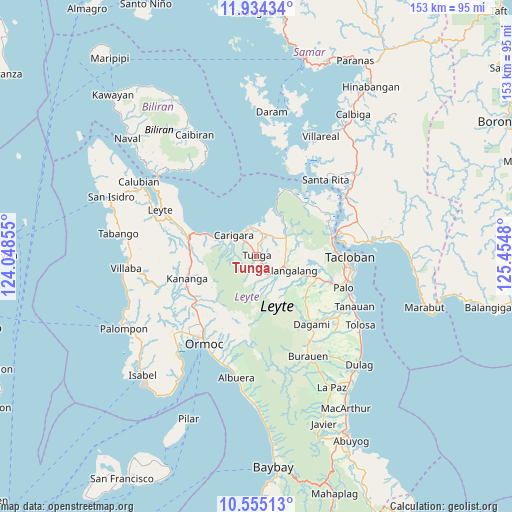
Tunga GPS coordinates[2]
11° 14' 44.016" North, 124° 45' 6.012" East
| Map corner | latitude | longitude |
|---|---|---|
| Upper-left | 11.93434°, | 124.04855° |
| Center: | 11.24556°, | 124.75167° |
| Lower-right: | 10.55513°, | 125.4548° |
| Map W x H: | 153.4×153.4 km | = 95.3×95.3mi |
| max Lat: | 20.78733° ⇑54% North |
| Tunga: | 11.24556° |
| min Lat: | ⇓46% South 4.65442° |
| min Long | Tunga | max Long |
| 117.04868° | 124.75167° | 126.58417° |
| W 83.2%⇐ | ⇒16.8% E |
Elevation
Elevation of Tunga is 62 m = 203 ft, and this is 25.9 m = 85 ft below average elevation for this country.
| Max E: |
2262 m = 7421 ft | 26.6% |
| Avg. | 87.9 m = 288 ft | |
| Tunga | 62 m = 203 ft | |
Min E: |
-2 m = -7 ft | 73.4% |
See also: Philippines elevation on elevation.city.
Geographical zone
Tunga is located in North Torrid zone (between Equator and Tropic of Cancer). Distance of Equator is 1250.4 km =777 mi to South.| Distance of | km | miles | from Tunga |
|---|---|---|---|
| North Pole | 8756.7 | 5441.2 | to North |
| Arctic Circle | 6150.8 | 3821.9 | to North |
| Tropic Cancer | 1355.5 | 842.3 | to North |
| Equator | 1250.4 | 777 | to South |


Nearby cities:
15 places around Tunga: (largest is in red/bold)
• Alangalang
11.3 km =7 mi,  112°
112°
• Barugo
8.9 km =5.5 mi,  350°
350°
• Canhandugan
12.7 km =7.9 mi,  166°
166°
• Capoocan
13.1 km =8.1 mi,  293°
293°
• Carigara
9.8 km =6.1 mi,  306°
306°
• Culasian
16.8 km =10.4 mi, 293°
• Guindapunan
8.1 km =5 mi,  321°
321°
• Jaro
7.7 km =4.8 mi,  153°
153°
• Lim-oo
16.9 km =10.5 mi,  231°
231°
• Limon
20.7 km =12.9 mi,  283°
283°
• Pastrana
19 km =11.8 mi,  129°
129°
• Pinamopoan
20.9 km =13 mi, 291°
• Rizal
20.3 km =12.6 mi,  247°
247°
• San Miguel
9.1 km =5.7 mi,  74°
74°
• Santa Fe
19.1 km =11.9 mi, 110°
Sources, notices
• [Note1] Compared only with cities in Philippines existing in our database
• [Src1] Map data: © OpenStreetMap contributors (CC-BY-SA)
• [Src2] Other city data from geonames.org with taken over terms of usage.
• [Src3] Geographical zone / Annual Mean Temperature by Robert A. Rohde @ Wikipedia
