San Miguel geodata
San Miguel (Central Visayas) is a seat of a third-order administrative division; located in Philippines in Asia/Manila (GMT+8) time zone. With population of 2,375 people, there are 3508 cities with bigger population in this country. Compared to other cities in Philippines, 68.3% of cities are located further ↑North; 76.3% of cities are located further ←West and 58.8% of cities have lower elevation than San Miguel. Note1


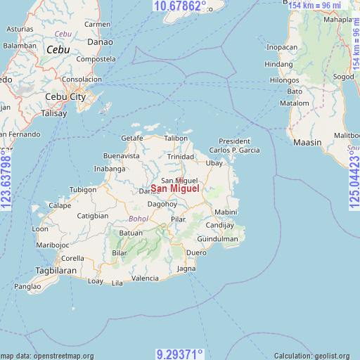
San Miguel GPS coordinates[2]
9° 59' 12.84" North, 124° 20' 27.96" East
| Map corner | latitude | longitude |
|---|---|---|
| Upper-left | 10.67862°, | 123.63798° |
| Center: | 9.9869°, | 124.3411° |
| Lower-right: | 9.29371°, | 125.04423° |
| Map W x H: | 154×154 km | = 95.7×95.7mi |
| max Lat: | 20.78733° ⇑68.3% North |
| San Miguel: | 9.9869° |
| min Lat: | ⇓31.7% South 4.65442° |
| min Long | San Miguel | max Long |
| 117.04868° | 124.3411° | 126.58417° |
| W 76.3%⇐ | ⇒23.7% E |
Elevation
Elevation of San Miguel is 32 m = 105 ft, and this is 55.9 m = 183 ft below average elevation for this country.
| Max E: |
2262 m = 7421 ft | 41.2% |
| Avg. | 87.9 m = 288 ft | |
| San Miguel | 32 m = 105 ft | |
Min E: |
-2 m = -7 ft | 58.8% |
See also: Philippines elevation on elevation.city.
Geographical zone
San Miguel is located in North Torrid zone (between Equator and Tropic of Cancer). Distance of Equator is 1110.4 km =690 mi to South.| Distance of | km | miles | from San Miguel |
|---|---|---|---|
| North Pole | 8896.6 | 5528.1 | to North |
| Arctic Circle | 6290.7 | 3908.9 | to North |
| Tropic Cancer | 1495.5 | 929.3 | to North |
| Equator | 1110.4 | 690 | to South |


Nearby cities:
15 places around San Miguel: (largest is in red/bold)
• Alicia
15.1 km =9.4 mi,  132°
132°
• Bien Unido
17.2 km =10.7 mi,  13°
13°
• Camambugan
13.3 km =8.3 mi,  53°
53°
• Dagohoy
11.5 km =7.1 mi,  213°
213°
• Danao
13.7 km =8.5 mi,  250°
250°
• Hinlayagan Ilaud
4.9 km =3 mi,  351°
351°
• La Hacienda
13 km =8.1 mi,  154°
154°
• Mahayag
6.4 km =4 mi, 205°
• Pilar
17.6 km =10.9 mi,  184°
184°
• San Miguel
11.4 km =7.1 mi,  188°
188°
• San Pascual
10.3 km =6.4 mi,  110°
110°
• San Roque
11.8 km =7.3 mi, 350°
• Tagum Norte
11.1 km =6.9 mi,  28°
28°
• Trinidad
10.3 km =6.4 mi,  1°
1°
• Ubay
16.4 km =10.2 mi,  61°
61°
Sources, notices
• [Note1] Compared only with cities in Philippines existing in our database
• [Src1] Map data: © OpenStreetMap contributors (CC-BY-SA)
• [Src2] Other city data from geonames.org with taken over terms of usage.
• [Src3] Geographical zone / Annual Mean Temperature by Robert A. Rohde @ Wikipedia
