San Clemente geodata
San Clemente (Central Luzon) is a seat of a third-order administrative division; located in Philippines in Asia/Manila (GMT+8) time zone. With population of 3,019 people, there are 2502 cities with bigger population in this country. Compared to other cities in Philippines, 84% of cities are located further ↓South; 94.6% of cities are located further →East and 52.3% of cities have lower elevation than San Clemente. Note1
Administrative division(s):
- Level 1: Central Luzon
- Level 2: Province of Tarlac
- Level 3: San Clemente


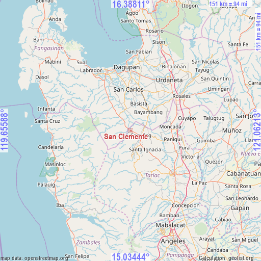
San Clemente GPS coordinates[2]
15° 42' 44.64" North, 120° 21' 32.4" East
| Map corner | latitude | longitude |
|---|---|---|
| Upper-left | 16.38811°, | 119.65588° |
| Center: | 15.7124°, | 120.359° |
| Lower-right: | 15.03444°, | 121.06213° |
| Map W x H: | 150.5×150.5 km | = 93.5×93.5mi |
| max Lat: | 20.78733° ⇑16% North |
| San Clemente: | 15.7124° |
| min Lat: | ⇓84% South 4.65442° |
| min Long | San Clemente | max Long |
| 117.04868° | 120.359° | 126.58417° |
| W 5.4%⇐ | ⇒94.6% E |
Elevation
Elevation of San Clemente is 25 m = 82 ft, and this is 62.9 m = 206 ft below average elevation for this country.
| Max E: |
2262 m = 7421 ft | 47.7% |
| Avg. | 87.9 m = 288 ft | |
| San Clemente | 25 m = 82 ft | |
Min E: |
-2 m = -7 ft | 52.3% |
See also: Philippines elevation on elevation.city.
Geographical zone
San Clemente is located in North Torrid zone (between Equator and Tropic of Cancer). Distance of this Northern Tropic circle is 858.9 km =533.7 mi to North.| Distance of | km | miles | from San Clemente |
|---|---|---|---|
| North Pole | 8260 | 5132.5 | to North |
| Arctic Circle | 5654.1 | 3513.3 | to North |
| Tropic Cancer | 858.9 | 533.7 | to North |
| Equator | 1747.1 | 1085.6 | to South |


Nearby cities:
15 places around San Clemente: (largest is in red/bold)
• Angatel
10.5 km =6.5 mi,  350°
350°
• Bacabac
7.5 km =4.7 mi,  79°
79°
• Bacsay
10.3 km =6.4 mi,  189°
189°
• Bamban
5.1 km =3.2 mi,  215°
215°
• Bilad
8.4 km =5.2 mi,  71°
71°
• Bobon Second
6.7 km =4.2 mi,  159°
159°
• Bogtong
5.8 km =3.6 mi,  326°
326°
• Camiling
6.4 km =4 mi,  116°
116°
• Malacampa
9.5 km =5.9 mi,  144°
144°
• Mangatarem
11 km =6.8 mi,  319°
319°
• Mayantoc
10.5 km =6.5 mi,  169°
169°
• Real
10.8 km =6.7 mi, 352°
• Santa Maria
10.5 km =6.5 mi, 136°
• Sinilian First
11 km =6.8 mi,  101°
101°
• Tocok
7.6 km =4.7 mi,  303°
303°
Sources, notices
• [Note1] Compared only with cities in Philippines existing in our database
• [Src1] Map data: © OpenStreetMap contributors (CC-BY-SA)
• [Src2] Other city data from geonames.org with taken over terms of usage.
• [Src3] Geographical zone / Annual Mean Temperature by Robert A. Rohde @ Wikipedia
