Bacsay geodata
Bacsay (Central Luzon) is a populated place; located in Philippines in Asia/Manila (GMT+8) time zone. With population of 2,615 people, there are 3082 cities with bigger population in this country. Compared to other cities in Philippines, 83% of cities are located further ↓South; 94.9% of cities are located further →East and 76.6% of cities have lower elevation than Bacsay. Note1


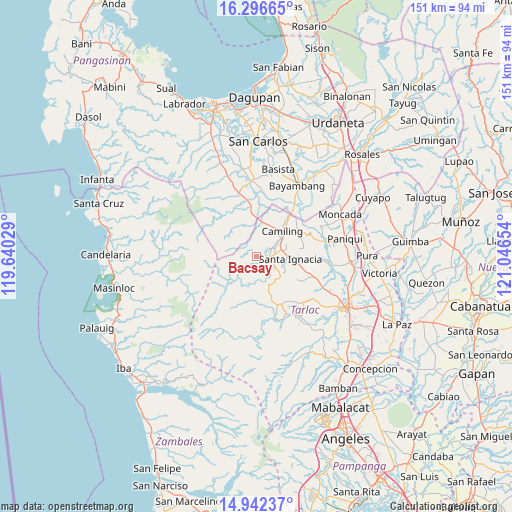
Bacsay GPS coordinates[2]
15° 37' 14.268" North, 120° 20' 36.276" East
| Map corner | latitude | longitude |
|---|---|---|
| Upper-left | 16.29665°, | 119.64029° |
| Center: | 15.62063°, | 120.34341° |
| Lower-right: | 14.94237°, | 121.04654° |
| Map W x H: | 150.6×150.6 km | = 93.6×93.6mi |
| max Lat: | 20.78733° ⇑17% North |
| Bacsay: | 15.62063° |
| min Lat: | ⇓83% South 4.65442° |
| min Long | Bacsay | max Long |
| 117.04868° | 120.34341° | 126.58417° |
| W 5.1%⇐ | ⇒94.9% E |
Elevation
Elevation of Bacsay is 74 m = 243 ft, and this is 13.9 m = 46 ft below average elevation for this country.
| Max E: |
2262 m = 7421 ft | 23.4% |
| Avg. | 87.9 m = 288 ft | |
| Bacsay | 74 m = 243 ft | |
Min E: |
-2 m = -7 ft | 76.6% |
See also: Philippines elevation on elevation.city.
Geographical zone
Bacsay is located in North Torrid zone (between Equator and Tropic of Cancer). Distance of this Northern Tropic circle is 869.1 km =540 mi to North.| Distance of | km | miles | from Bacsay |
|---|---|---|---|
| North Pole | 8270.2 | 5138.9 | to North |
| Arctic Circle | 5664.3 | 3519.6 | to North |
| Tropic Cancer | 869.1 | 540 | to North |
| Equator | 1736.9 | 1079.3 | to South |


Nearby cities:
15 places around Bacsay: (largest is in red/bold)
• Bacabac
14.7 km =9.1 mi,  38°
38°
• Bamban
6.1 km =3.8 mi,  348°
348°
• Bobon Second
5.7 km =3.5 mi,  45°
45°
• Camiling
10.4 km =6.5 mi, 45°
• Malacampa
7.7 km =4.8 mi,  70°
70°
• Mamonit
6.8 km =4.2 mi,  123°
123°
• Mayantoc
3.6 km =2.2 mi,  91°
91°
• Nambalan
12.7 km =7.9 mi,  100°
100°
• San Clemente
10.3 km =6.4 mi,  9°
9°
• San Francisco
10 km =6.2 mi,  84°
84°
• Santa Ignacia
9.9 km =6.2 mi, 92°
• Santa Ines West
14.8 km =9.2 mi, 118°
• Santa Maria
9.2 km =5.7 mi, 73°
• Sinilian First
14.8 km =9.2 mi,  56°
56°
• Tocok
15.1 km =9.4 mi,  342°
342°
Sources, notices
• [Note1] Compared only with cities in Philippines existing in our database
• [Src1] Map data: © OpenStreetMap contributors (CC-BY-SA)
• [Src2] Other city data from geonames.org with taken over terms of usage.
• [Src3] Geographical zone / Annual Mean Temperature by Robert A. Rohde @ Wikipedia
