Santa Maria geodata
Santa Maria (Central Luzon) is a populated place; located in Philippines in Asia/Manila (GMT+8) time zone. With population of 2,420 people, there are 3427 cities with bigger population in this country. Compared to other cities in Philippines, 83.2% of cities are located further ↓South; 93% of cities are located further →East and 63.6% of cities have lower elevation than Santa Maria. Note1


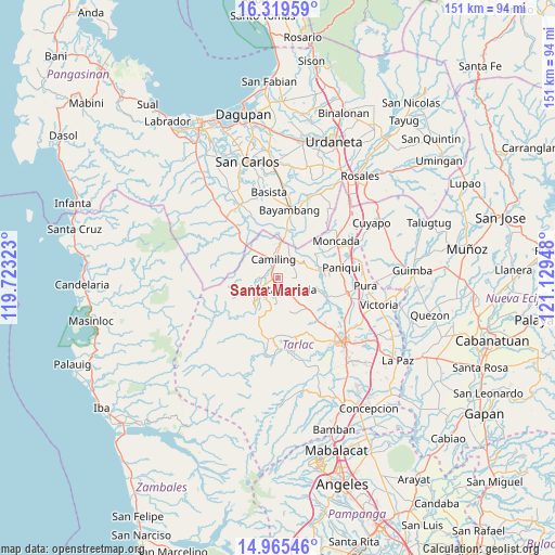
Santa Maria GPS coordinates[2]
15° 38' 37.14" North, 120° 25' 34.86" East
| Map corner | latitude | longitude |
|---|---|---|
| Upper-left | 16.31959°, | 119.72323° |
| Center: | 15.64365°, | 120.42635° |
| Lower-right: | 14.96546°, | 121.12948° |
| Map W x H: | 150.6×150.6 km | = 93.6×93.6mi |
| max Lat: | 20.78733° ⇑16.8% North |
| Santa Maria: | 15.64365° |
| min Lat: | ⇓83.2% South 4.65442° |
| min Long | Santa Maria | max Long |
| 117.04868° | 120.42635° | 126.58417° |
| W 7%⇐ | ⇒93% E |
Elevation
Elevation of Santa Maria is 39 m = 128 ft, and this is 48.9 m = 160 ft below average elevation for this country.
| Max E: |
2262 m = 7421 ft | 36.4% |
| Avg. | 87.9 m = 288 ft | |
| Santa Maria | 39 m = 128 ft | |
Min E: |
-2 m = -7 ft | 63.6% |
See also: Philippines elevation on elevation.city.
Geographical zone
Santa Maria is located in North Torrid zone (between Equator and Tropic of Cancer). Distance of this Northern Tropic circle is 866.5 km =538.4 mi to North.| Distance of | km | miles | from Santa Maria |
|---|---|---|---|
| North Pole | 8267.7 | 5137.3 | to North |
| Arctic Circle | 5661.8 | 3518.1 | to North |
| Tropic Cancer | 866.5 | 538.4 | to North |
| Equator | 1739.4 | 1080.8 | to South |


Nearby cities:
15 places around Santa Maria: (largest is in red/bold)
• Bacabac
9 km =5.6 mi,  1°
1°
• Bacsay
9.2 km =5.7 mi,  253°
253°
• Balaoang
9.7 km =6 mi,  76°
76°
• Bilad
10.4 km =6.5 mi, 4°
• Bobon Second
5 km =3.1 mi,  286°
286°
• Camiling
5 km =3.1 mi,  343°
343°
• Mabilang
7.5 km =4.7 mi,  62°
62°
• Malacampa
1.6 km =1 mi,  268°
268°
• Mamonit
7 km =4.3 mi,  207°
207°
• Mayantoc
5.9 km =3.7 mi,  243°
243°
• Nambalan
6.1 km =3.8 mi,  143°
143°
• San Francisco
2 km =1.2 mi,  146°
146°
• Santa Ignacia
3.1 km =1.9 mi,  161°
161°
• Sinilian First
6.6 km =4.1 mi,  32°
32°
• Vargas
8.6 km =5.3 mi,  130°
130°
Sources, notices
• [Note1] Compared only with cities in Philippines existing in our database
• [Src1] Map data: © OpenStreetMap contributors (CC-BY-SA)
• [Src2] Other city data from geonames.org with taken over terms of usage.
• [Src3] Geographical zone / Annual Mean Temperature by Robert A. Rohde @ Wikipedia
