Bilad geodata
Bilad (Central Luzon) is a populated place; located in Philippines in Asia/Manila (GMT+8) time zone. With population of 2,778 people, there are 2824 cities with bigger population in this country. Compared to other cities in Philippines, 84.3% of cities are located further ↓South; 92.8% of cities are located further →East and 54.5% of cities have higher elevation than Bilad. Note1


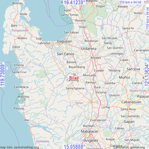
Bilad GPS coordinates[2]
15° 44' 12.336" North, 120° 25' 59.556" East
| Map corner | latitude | longitude |
|---|---|---|
| Upper-left | 16.41239°, | 119.73009° |
| Center: | 15.73676°, | 120.43321° |
| Lower-right: | 15.05888°, | 121.13634° |
| Map W x H: | 150.5×150.5 km | = 93.5×93.5mi |
| max Lat: | 20.78733° ⇑15.7% North |
| Bilad: | 15.73676° |
| min Lat: | ⇓84.3% South 4.65442° |
| min Long | Bilad | max Long |
| 117.04868° | 120.43321° | 126.58417° |
| W 7.2%⇐ | ⇒92.8% E |
Elevation
Elevation of Bilad is 20 m = 66 ft, and this is 67.9 m = 223 ft below average elevation for this country.
| Max E: |
2262 m = 7421 ft | 54.5% |
| Avg. | 87.9 m = 288 ft | |
| Bilad | 20 m = 66 ft | |
Min E: |
-2 m = -7 ft | 45.5% |
See also: Philippines elevation on elevation.city.
Geographical zone
Bilad is located in North Torrid zone (between Equator and Tropic of Cancer). Distance of this Northern Tropic circle is 856.2 km =532 mi to North.| Distance of | km | miles | from Bilad |
|---|---|---|---|
| North Pole | 8257.3 | 5130.8 | to North |
| Arctic Circle | 5651.4 | 3511.6 | to North |
| Tropic Cancer | 856.2 | 532 | to North |
| Equator | 1749.8 | 1087.3 | to South |


Nearby cities:
15 places around Bilad: (largest is in red/bold)
• Bacabac
1.4 km =0.9 mi,  202°
202°
• Baluyot
7.2 km =4.5 mi,  24°
24°
• Bautista
8.7 km =5.4 mi,  53°
53°
• Bayambang
8.8 km =5.5 mi, 15°
• Bical Norte
8.7 km =5.4 mi,  1°
1°
• Bobon Second
10.5 km =6.5 mi,  211°
211°
• Camiling
6 km =3.7 mi, 201°
• Mabilang
9 km =5.6 mi,  139°
139°
• San Clemente
8.4 km =5.2 mi,  251°
251°
• San Gabriel First
4.1 km =2.5 mi,  37°
37°
• Santa Maria
10.4 km =6.5 mi,  184°
184°
• Sapang
10.5 km =6.5 mi,  110°
110°
• Sinilian First
5.6 km =3.5 mi,  149°
149°
• Tanolong
7.8 km =4.8 mi,  344°
344°
• Tococ East
9.8 km =6.1 mi,  355°
355°
Sources, notices
• [Note1] Compared only with cities in Philippines existing in our database
• [Src1] Map data: © OpenStreetMap contributors (CC-BY-SA)
• [Src2] Other city data from geonames.org with taken over terms of usage.
• [Src3] Geographical zone / Annual Mean Temperature by Robert A. Rohde @ Wikipedia
