Romblon geodata
Romblon (Mimaropa) is a seat of a third-order administrative division; located in Philippines in Asia/Manila (GMT+8) time zone. With population of 15,316 people, there are 439 cities with bigger population in this country. Compared to other cities in Philippines, 55.4% of cities are located further ↓South; 57.5% of cities are located further →East and 65.1% of cities have higher elevation than Romblon. Note1


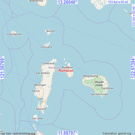
Romblon GPS coordinates[2]
12° 34' 30.468" North, 122° 16' 14.916" East
| Map corner | latitude | longitude |
|---|---|---|
| Upper-left | 13.26046°, | 121.56769° |
| Center: | 12.57513°, | 122.27081° |
| Lower-right: | 11.88797°, | 122.97394° |
| Map W x H: | 152.6×152.6 km | = 94.8×94.8mi |
| max Lat: | 20.78733° ⇑44.6% North |
| Romblon: | 12.57513° |
| min Lat: | ⇓55.4% South 4.65442° |
| min Long | Romblon | max Long |
| 117.04868° | 122.27081° | 126.58417° |
| W 42.5%⇐ | ⇒57.5% E |
Elevation
Elevation of Romblon is 14 m = 46 ft, and this is 73.9 m = 242 ft below average elevation for this country.
| Max E: |
2262 m = 7421 ft | 65.1% |
| Avg. | 87.9 m = 288 ft | |
| Romblon | 14 m = 46 ft | |
Min E: |
-2 m = -7 ft | 34.9% |
See also: Philippines elevation on elevation.city.
Geographical zone
Romblon is located in North Torrid zone (between Equator and Tropic of Cancer). Distance of this Northern Tropic circle is 1207.7 km =750.4 mi to North.| Distance of | km | miles | from Romblon |
|---|---|---|---|
| North Pole | 8608.8 | 5349.3 | to North |
| Arctic Circle | 6003 | 3730.1 | to North |
| Tropic Cancer | 1207.7 | 750.4 | to North |
| Equator | 1398.2 | 868.8 | to South |


Nearby cities:
15 places around Romblon: (largest is in red/bold)
• Alad
5.3 km =3.3 mi,  331°
331°
• Cajimos
2.2 km =1.4 mi,  12°
12°
• Calatrava
22.2 km =13.8 mi,  282°
282°
• Carmen
16.9 km =10.5 mi,  286°
286°
• Concepcion
27.6 km =17.1 mi,  224°
224°
• Dapawan
32.3 km =20.1 mi,  234°
234°
• Dobdoban
17 km =10.6 mi,  269°
269°
• Gabawan
32.4 km =20.1 mi,  239°
239°
• Libertad
31.5 km =19.6 mi, 244°
• Magdiwang
28.4 km =17.6 mi,  111°
111°
• Panique
29.7 km =18.5 mi,  249°
249°
• Pato-o
27.4 km =17 mi, 234°
• San Agustin
15.1 km =9.4 mi, 267°
• Tampayan
29.9 km =18.6 mi, 107°
• Tomingad
30.8 km =19.1 mi, 241°
Sources, notices
• [Note1] Compared only with cities in Philippines existing in our database
• [Src1] Map data: © OpenStreetMap contributors (CC-BY-SA)
• [Src2] Other city data from geonames.org with taken over terms of usage.
• [Src3] Geographical zone / Annual Mean Temperature by Robert A. Rohde @ Wikipedia
