Calatrava geodata
Calatrava (Mimaropa) is a seat of a third-order administrative division; located in Philippines in Asia/Manila (GMT+8) time zone. With population of 2,225 people, there are 3837 cities with bigger population in this country. Compared to other cities in Philippines, 55.7% of cities are located further ↓South; 59.3% of cities are located further →East and 85.4% of cities have higher elevation than Calatrava. Note1


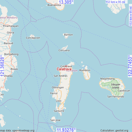
Calatrava GPS coordinates[2]
12° 37' 11.28" North, 122° 4' 17.04" East
| Map corner | latitude | longitude |
|---|---|---|
| Upper-left | 13.305°, | 121.36828° |
| Center: | 12.6198°, | 122.0714° |
| Lower-right: | 11.93276°, | 122.77453° |
| Map W x H: | 152.6×152.6 km | = 94.8×94.8mi |
| max Lat: | 20.78733° ⇑44.3% North |
| Calatrava: | 12.6198° |
| min Lat: | ⇓55.7% South 4.65442° |
| min Long | Calatrava | max Long |
| 117.04868° | 122.0714° | 126.58417° |
| W 40.7%⇐ | ⇒59.3% E |
Elevation
Elevation of Calatrava is 8 m = 26 ft, and this is 79.9 m = 262 ft below average elevation for this country.
| Max E: |
2262 m = 7421 ft | 85.4% |
| Avg. | 87.9 m = 288 ft | |
| Calatrava | 8 m = 26 ft | |
Min E: |
-2 m = -7 ft | 14.6% |
See also: Philippines elevation on elevation.city.
Geographical zone
Calatrava is located in North Torrid zone (between Equator and Tropic of Cancer). Distance of this Northern Tropic circle is 1202.7 km =747.3 mi to North.| Distance of | km | miles | from Calatrava |
|---|---|---|---|
| North Pole | 8603.9 | 5346.2 | to North |
| Arctic Circle | 5998 | 3727 | to North |
| Tropic Cancer | 1202.7 | 747.3 | to North |
| Equator | 1403.2 | 871.9 | to South |


Nearby cities:
15 places around Calatrava: (largest is in red/bold)
• Alad
19.1 km =11.9 mi,  90°
90°
• Cajimos
22.3 km =13.9 mi,  97°
97°
• Carmen
5.4 km =3.4 mi, 93°
• Concepcion
24.8 km =15.4 mi,  174°
174°
• Corcuera
18.3 km =11.4 mi,  352°
352°
• Dapawan
24.1 km =15 mi,  191°
191°
• Dobdoban
6.8 km =4.2 mi,  137°
137°
• Gabawan
22.3 km =13.9 mi,  196°
196°
• Libertad
19.7 km =12.2 mi, 200°
• Odiongan
25.7 km =16 mi, 199°
• Panique
16.7 km =10.4 mi, 201°
• Pato-o
21.1 km =13.1 mi,  181°
181°
• Romblon
22.2 km =13.8 mi, 102°
• San Agustin
8.6 km =5.3 mi,  131°
131°
• Tomingad
20.4 km =12.7 mi, 195°
Sources, notices
• [Note1] Compared only with cities in Philippines existing in our database
• [Src1] Map data: © OpenStreetMap contributors (CC-BY-SA)
• [Src2] Other city data from geonames.org with taken over terms of usage.
• [Src3] Geographical zone / Annual Mean Temperature by Robert A. Rohde @ Wikipedia
