Ginatilan geodata
Ginatilan (Central Visayas) is a seat of a third-order administrative division; located in Philippines in Asia/Manila (GMT+8) time zone. With population of 2,699 people, there are 2948 cities with bigger population in this country. Compared to other cities in Philippines, 72.8% of cities are located further ↑North; 58.6% of cities are located further ←West and 73.2% of cities have higher elevation than Ginatilan. Note1


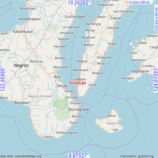
Ginatilan GPS coordinates[2]
9° 34' 9.84" North, 123° 18' 46.08" East
| Map corner | latitude | longitude |
|---|---|---|
| Upper-left | 10.26202°, | 122.60968° |
| Center: | 9.5694°, | 123.3128° |
| Lower-right: | 8.87537°, | 124.01593° |
| Map W x H: | 154.2×154.2 km | = 95.8×95.8mi |
| max Lat: | 20.78733° ⇑72.8% North |
| Ginatilan: | 9.5694° |
| min Lat: | ⇓27.2% South 4.65442° |
| min Long | Ginatilan | max Long |
| 117.04868° | 123.3128° | 126.58417° |
| W 58.6%⇐ | ⇒41.4% E |
Elevation
Elevation of Ginatilan is 11 m = 36 ft, and this is 76.9 m = 252 ft below average elevation for this country.
| Max E: |
2262 m = 7421 ft | 73.2% |
| Avg. | 87.9 m = 288 ft | |
| Ginatilan | 11 m = 36 ft | |
Min E: |
-2 m = -7 ft | 26.8% |
See also: Philippines elevation on elevation.city.
Geographical zone
Ginatilan is located in North Torrid zone (between Equator and Tropic of Cancer). Distance of Equator is 1064 km =661.1 mi to South.| Distance of | km | miles | from Ginatilan |
|---|---|---|---|
| North Pole | 8943 | 5556.9 | to North |
| Arctic Circle | 6337.2 | 3937.8 | to North |
| Tropic Cancer | 1541.9 | 958.1 | to North |
| Equator | 1064 | 661.1 | to South |


Nearby cities:
15 places around Ginatilan: (largest is in red/bold)
• Alegria
18 km =11.2 mi,  9°
9°
• Becerril
16.3 km =10.1 mi,  55°
55°
• Jugno
16.4 km =10.2 mi,  226°
226°
• Lepanto
16.1 km =10 mi,  37°
37°
• Mainit
16 km =9.9 mi,  161°
161°
• Malabuyoc
9.3 km =5.8 mi, 8°
• Montaneza
12.9 km =8 mi, 7°
• Okiot
16 km =9.9 mi,  268°
268°
• Oslob
14.1 km =8.8 mi,  112°
112°
• Polo
17.5 km =10.9 mi,  236°
236°
• Samboan
4.7 km =2.9 mi,  187°
187°
• Santander Poblacion
16.3 km =10.1 mi,  169°
169°
• Talangnan
7.6 km =4.7 mi,  18°
18°
• Tandayag
15.7 km =9.8 mi,  215°
215°
• Tanjay
18 km =11.2 mi,  250°
250°
Sources, notices
• [Note1] Compared only with cities in Philippines existing in our database
• [Src1] Map data: © OpenStreetMap contributors (CC-BY-SA)
• [Src2] Other city data from geonames.org with taken over terms of usage.
• [Src3] Geographical zone / Annual Mean Temperature by Robert A. Rohde @ Wikipedia
