Ragandang geodata
Ragandang (Soccsksargen) is a populated place; located in Philippines in Asia/Manila (GMT+8) time zone. With population of 2,216 people, there are 3855 cities with bigger population in this country. Compared to other cities in Philippines, 94.4% of cities are located further ↑North; 73.2% of cities are located further ←West and 61.5% of cities have lower elevation than Ragandang. Note1
Administrative division(s):
- Level 1: Soccsksargen
- Level 2: Province of Sultan Kudarat
- Level 3: Lebak


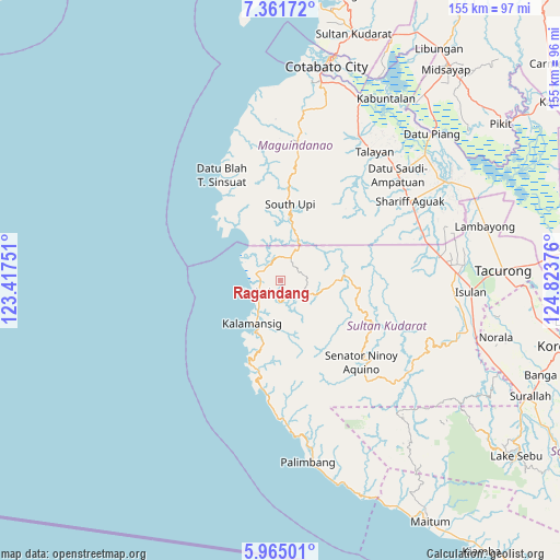
Ragandang GPS coordinates[2]
6° 39' 49.896" North, 124° 7' 14.268" East
| Map corner | latitude | longitude |
|---|---|---|
| Upper-left | 7.36172°, | 123.41751° |
| Center: | 6.66386°, | 124.12063° |
| Lower-right: | 5.96501°, | 124.82376° |
| Map W x H: | 155.3×155.3 km | = 96.5×96.5mi |
| max Lat: | 20.78733° ⇑94.4% North |
| Ragandang: | 6.66386° |
| min Lat: | ⇓5.6% South 4.65442° |
| min Long | Ragandang | max Long |
| 117.04868° | 124.12063° | 126.58417° |
| W 73.2%⇐ | ⇒26.8% E |
Elevation
Elevation of Ragandang is 36 m = 118 ft, and this is 51.9 m = 170 ft below average elevation for this country.
| Max E: |
2262 m = 7421 ft | 38.5% |
| Avg. | 87.9 m = 288 ft | |
| Ragandang | 36 m = 118 ft | |
Min E: |
-2 m = -7 ft | 61.5% |
See also: Philippines elevation on elevation.city.
Geographical zone
Ragandang is located in North Torrid zone (between Equator and Tropic of Cancer). Distance of Equator is 741 km =460.4 mi to South.| Distance of | km | miles | from Ragandang |
|---|---|---|---|
| North Pole | 9266.1 | 5757.7 | to North |
| Arctic Circle | 6660.2 | 4138.5 | to North |
| Tropic Cancer | 1865 | 1158.9 | to North |
| Equator | 741 | 460.4 | to South |


Nearby cities:
15 places around Ragandang: (largest is in red/bold)
• Bantogon
17.4 km =10.8 mi,  213°
213°
• Basak
7.8 km =4.8 mi,  25°
25°
• Gadung
19 km =11.8 mi,  324°
324°
• Kalamangog
8.9 km =5.5 mi, 320°
• Kalamansig
14.6 km =9.1 mi, 211°
• Kulaman
23 km =14.3 mi,  189°
189°
• Lebak
6.4 km =4 mi,  249°
249°
• Limulan
10.9 km =6.8 mi,  216°
216°
• Noling
2.3 km =1.4 mi,  258°
258°
• Puloypuloy
4.2 km =2.6 mi, 220°
• Puricay
6.2 km =3.9 mi,  293°
293°
• Sangay
25.7 km =16 mi,  199°
199°
• South Upi
19.1 km =11.9 mi,  9°
9°
• Taguisa
10.1 km =6.3 mi, 292°
• Tran
9.6 km =6 mi,  310°
310°
Sources, notices
• [Note1] Compared only with cities in Philippines existing in our database
• [Src1] Map data: © OpenStreetMap contributors (CC-BY-SA)
• [Src2] Other city data from geonames.org with taken over terms of usage.
• [Src3] Geographical zone / Annual Mean Temperature by Robert A. Rohde @ Wikipedia
