Lebak geodata
Lebak (Soccsksargen) is a seat of a third-order administrative division; located in Philippines in Asia/Manila (GMT+8) time zone. In our database, there are 4166 cities with bigger population. Compared to other cities in Philippines, 94.6% of cities are located further ↑North; 72.4% of cities are located further ←West and 80.7% of cities have higher elevation than Lebak. Note1
Administrative division(s):
- Level 1: Soccsksargen
- Level 2: Province of Sultan Kudarat
- Level 3: Lebak


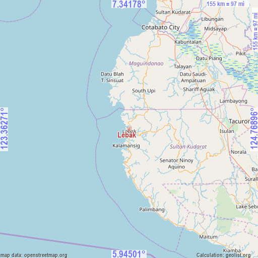
Lebak GPS coordinates[2]
6° 38' 38.004" North, 124° 3' 56.988" East
| Map corner | latitude | longitude |
|---|---|---|
| Upper-left | 7.34178°, | 123.36271° |
| Center: | 6.64389°, | 124.06583° |
| Lower-right: | 5.94501°, | 124.76896° |
| Map W x H: | 155.3×155.3 km | = 96.5×96.5mi |
| max Lat: | 20.78733° ⇑94.6% North |
| Lebak: | 6.64389° |
| min Lat: | ⇓5.4% South 4.65442° |
| min Long | Lebak | max Long |
| 117.04868° | 124.06583° | 126.58417° |
| W 72.4%⇐ | ⇒27.6% E |
Elevation
Elevation of Lebak is 9 m = 30 ft, and this is 78.9 m = 259 ft below average elevation for this country.
| Max E: |
2262 m = 7421 ft | 80.7% |
| Avg. | 87.9 m = 288 ft | |
| Lebak | 9 m = 30 ft | |
Min E: |
-2 m = -7 ft | 19.3% |
See also: Philippines elevation on elevation.city.
Geographical zone
Lebak is located in North Torrid zone (between Equator and Tropic of Cancer). Distance of Equator is 738.7 km =459 mi to South.| Distance of | km | miles | from Lebak |
|---|---|---|---|
| North Pole | 9268.3 | 5759.1 | to North |
| Arctic Circle | 6662.4 | 4139.8 | to North |
| Tropic Cancer | 1867.2 | 1160.2 | to North |
| Equator | 738.7 | 459 | to South |


Nearby cities:
15 places around Lebak: (largest is in red/bold)
• Bantogon
12.8 km =8 mi,  196°
196°
• Basak
13.2 km =8.2 mi,  45°
45°
• Gadung
18.3 km =11.4 mi,  343°
343°
• Kalamangog
9.1 km =5.7 mi,  2°
2°
• Kalamansig
10.4 km =6.5 mi,  189°
189°
• Kulaman
20.6 km =12.8 mi,  173°
173°
• Limulan
6.5 km =4 mi,  183°
183°
• Noling
4.2 km =2.6 mi,  64°
64°
• Puloypuloy
3.5 km =2.2 mi,  106°
106°
• Puricay
4.7 km =2.9 mi,  5°
5°
• Ragandang
6.4 km =4 mi,  69°
69°
• Sangay
22.2 km =13.8 mi, 186°
• South Upi
23 km =14.3 mi,  23°
23°
• Taguisa
6.9 km =4.3 mi,  331°
331°
• Tran
8.6 km =5.3 mi,  351°
351°
Sources, notices
• [Note1] Compared only with cities in Philippines existing in our database
• [Src1] Map data: © OpenStreetMap contributors (CC-BY-SA)
• [Src2] Other city data from geonames.org with taken over terms of usage.
• [Src3] Geographical zone / Annual Mean Temperature by Robert A. Rohde @ Wikipedia
