Noling geodata
Noling (Soccsksargen) is a populated place; located in Philippines in Asia/Manila (GMT+8) time zone. With population of 2,989 people, there are 2540 cities with bigger population in this country. Compared to other cities in Philippines, 94.4% of cities are located further ↑North; 72.8% of cities are located further ←West and 85.4% of cities have higher elevation than Noling. Note1
Administrative division(s):
- Level 1: Soccsksargen
- Level 2: Province of Sultan Kudarat
- Level 3: Lebak


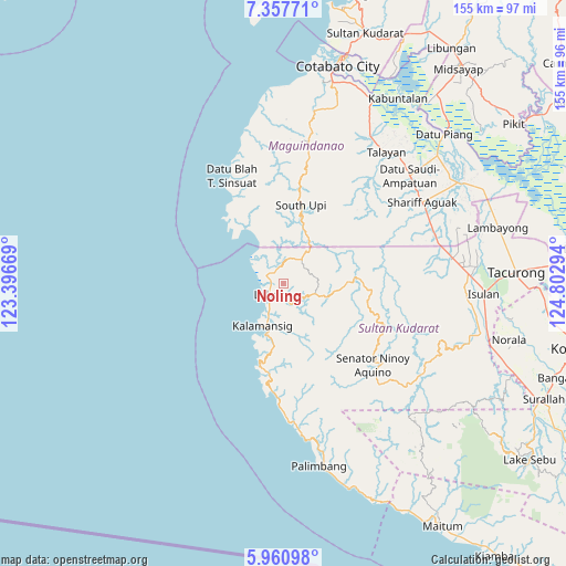
Noling GPS coordinates[2]
6° 39' 35.424" North, 124° 5' 59.316" East
| Map corner | latitude | longitude |
|---|---|---|
| Upper-left | 7.35771°, | 123.39669° |
| Center: | 6.65984°, | 124.09981° |
| Lower-right: | 5.96098°, | 124.80294° |
| Map W x H: | 155.3×155.3 km | = 96.5×96.5mi |
| max Lat: | 20.78733° ⇑94.4% North |
| Noling: | 6.65984° |
| min Lat: | ⇓5.6% South 4.65442° |
| min Long | Noling | max Long |
| 117.04868° | 124.09981° | 126.58417° |
| W 72.8%⇐ | ⇒27.2% E |
Elevation
Elevation of Noling is 8 m = 26 ft, and this is 79.9 m = 262 ft below average elevation for this country.
| Max E: |
2262 m = 7421 ft | 85.4% |
| Avg. | 87.9 m = 288 ft | |
| Noling | 8 m = 26 ft | |
Min E: |
-2 m = -7 ft | 14.6% |
See also: Philippines elevation on elevation.city.
Geographical zone
Noling is located in North Torrid zone (between Equator and Tropic of Cancer). Distance of Equator is 740.5 km =460.1 mi to South.| Distance of | km | miles | from Noling |
|---|---|---|---|
| North Pole | 9266.6 | 5758 | to North |
| Arctic Circle | 6660.7 | 4138.8 | to North |
| Tropic Cancer | 1865.4 | 1159.1 | to North |
| Equator | 740.5 | 460.1 | to South |


Nearby cities:
15 places around Noling: (largest is in red/bold)
• Bantogon
15.9 km =9.9 mi,  207°
207°
• Basak
9.4 km =5.8 mi,  37°
37°
• Gadung
18.1 km =11.2 mi,  330°
330°
• Kalamangog
8.1 km =5 mi, 334°
• Kalamansig
13.2 km =8.2 mi,  204°
204°
• Kulaman
22.3 km =13.9 mi,  183°
183°
• Lebak
4.2 km =2.6 mi,  244°
244°
• Limulan
9.3 km =5.8 mi, 206°
• Puloypuloy
2.8 km =1.7 mi,  188°
188°
• Puricay
4.4 km =2.7 mi,  311°
311°
• Ragandang
2.3 km =1.4 mi,  78°
78°
• Sangay
24.7 km =15.3 mi, 194°
• South Upi
20.1 km =12.5 mi,  16°
16°
• Taguisa
8.3 km =5.2 mi,  301°
301°
• Tran
8.3 km =5.2 mi,  323°
323°
Sources, notices
• [Note1] Compared only with cities in Philippines existing in our database
• [Src1] Map data: © OpenStreetMap contributors (CC-BY-SA)
• [Src2] Other city data from geonames.org with taken over terms of usage.
• [Src3] Geographical zone / Annual Mean Temperature by Robert A. Rohde @ Wikipedia
