Pondaguitan geodata
Pondaguitan (Davao) is a populated place; located in Philippines in Asia/Manila (GMT+8) time zone. With population of 2,143 people, there are 4003 cities with bigger population in this country. Compared to other cities in Philippines, 96.5% of cities are located further ↑North; 99% of cities are located further ←West and 52.3% of cities have lower elevation than Pondaguitan. Note1
Administrative division(s):
- Level 1: Davao
- Level 2: Province of Davao Oriental
- Level 3: Governor Generoso


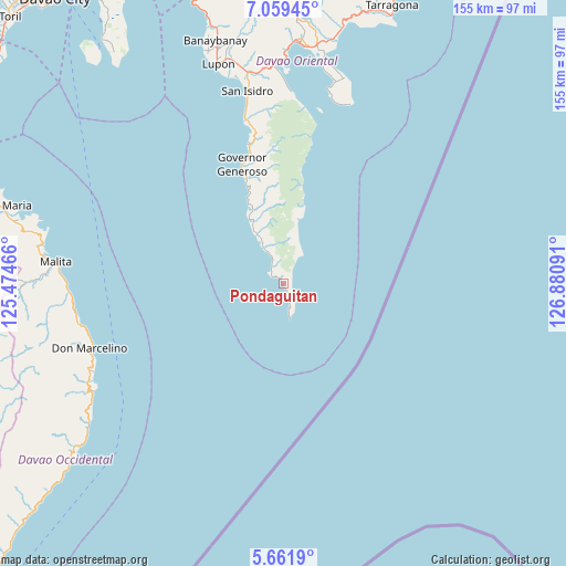
Pondaguitan GPS coordinates[2]
6° 21' 40.14" North, 126° 10' 40.008" East
| Map corner | latitude | longitude |
|---|---|---|
| Upper-left | 7.05945°, | 125.47466° |
| Center: | 6.36115°, | 126.17778° |
| Lower-right: | 5.6619°, | 126.88091° |
| Map W x H: | 155.4×155.4 km | = 96.6×96.6mi |
| max Lat: | 20.78733° ⇑96.5% North |
| Pondaguitan: | 6.36115° |
| min Lat: | ⇓3.5% South 4.65442° |
| min Long | Pondaguitan | max Long |
| 117.04868° | 126.17778° | 126.58417° |
| W 99%⇐ | ⇒1% E |
Elevation
Elevation of Pondaguitan is 25 m = 82 ft, and this is 62.9 m = 206 ft below average elevation for this country.
| Max E: |
2262 m = 7421 ft | 47.7% |
| Avg. | 87.9 m = 288 ft | |
| Pondaguitan | 25 m = 82 ft | |
Min E: |
-2 m = -7 ft | 52.3% |
See also: Philippines elevation on elevation.city.
Geographical zone
Pondaguitan is located in North Torrid zone (between Equator and Tropic of Cancer). Distance of Equator is 707.3 km =439.5 mi to South.| Distance of | km | miles | from Pondaguitan |
|---|---|---|---|
| North Pole | 9299.8 | 5778.6 | to North |
| Arctic Circle | 6693.9 | 4159.4 | to North |
| Tropic Cancer | 1898.6 | 1179.7 | to North |
| Equator | 707.3 | 439.5 | to South |


Nearby cities:
15 places around Pondaguitan: (largest is in red/bold)
• Baon
49.3 km =30.6 mi,  348°
348°
• Batobato
52.6 km =32.7 mi, 348°
• Bitaogan
46.6 km =29 mi, 346°
• La Union
39.4 km =24.5 mi, 345°
• Lapuan
58 km =36 mi,  245°
245°
• Luzon
19.8 km =12.3 mi,  332°
332°
• Magdug
22.7 km =14.1 mi,  336°
336°
• Nangan
13.7 km =8.5 mi, 334°
• Sigaboy
34.6 km =21.5 mi, 340°
• Surup
4.8 km =3 mi,  312°
312°
• Talagutong
57.4 km =35.7 mi,  259°
259°
• Talisay
40.8 km =25.4 mi, 347°
• Tamisan
55.3 km =34.4 mi,  13°
13°
• Tibanbang
31.1 km =19.3 mi, 345°
• Tiblawan
15.1 km =9.4 mi, 329°
Sources, notices
• [Note1] Compared only with cities in Philippines existing in our database
• [Src1] Map data: © OpenStreetMap contributors (CC-BY-SA)
• [Src2] Other city data from geonames.org with taken over terms of usage.
• [Src3] Geographical zone / Annual Mean Temperature by Robert A. Rohde @ Wikipedia
