La Union geodata
La Union (Davao) is a populated place; located in Philippines in Asia/Manila (GMT+8) time zone. With population of 5,221 people, there are 1223 cities with bigger population in this country. Compared to other cities in Philippines, 93.9% of cities are located further ↑North; 98.4% of cities are located further ←West and 56.1% of cities have higher elevation than La Union. Note1


La Union GPS coordinates[2]
6° 42' 14.868" North, 126° 5' 16.728" East
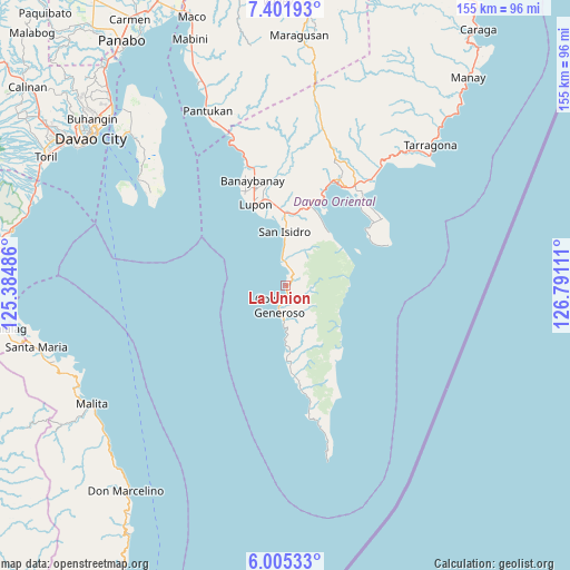
| Map corner | latitude | longitude |
|---|---|---|
| Upper-left | 7.40193°, | 125.38486° |
| Center: | 6.70413°, | 126.08798° |
| Lower-right: | 6.00533°, | 126.79111° |
| Map W x H: | 155.3×155.3 km | = 96.5×96.5mi |
| max Lat: | 20.78733° ⇑93.9% North |
| La Union: | 6.70413° |
| min Lat: | ⇓6.1% South 4.65442° |
| min Long | La Union | max Long |
| 117.04868° | 126.08798° | 126.58417° |
| W 98.4%⇐ | ⇒1.6% E |
Elevation
Elevation of La Union is 19 m = 62 ft, and this is 68.9 m = 226 ft below average elevation for this country.
| Max E: |
2262 m = 7421 ft | 56.1% |
| Avg. | 87.9 m = 288 ft | |
| La Union | 19 m = 62 ft | |
Min E: |
-2 m = -7 ft | 43.9% |
See also: Philippines elevation on elevation.city.
Geographical zone
La Union is located in North Torrid zone (between Equator and Tropic of Cancer). Distance of Equator is 745.4 km =463.2 mi to South.| Distance of | km | miles | from La Union |
|---|---|---|---|
| North Pole | 9261.6 | 5754.9 | to North |
| Arctic Circle | 6655.7 | 4135.7 | to North |
| Tropic Cancer | 1860.5 | 1156.1 | to North |
| Equator | 745.4 | 463.2 | to South |


Nearby cities:
15 places around La Union: (largest is in red/bold)
• Baon
10.2 km =6.3 mi,  359°
359°
• Batobato
13.5 km =8.4 mi, 358°
• Bitaogan
7.2 km =4.5 mi,  350°
350°
• Davan
24.5 km =15.2 mi,  17°
17°
• Ilangay
23.6 km =14.7 mi, 349°
• Lupon
23.2 km =14.4 mi,  338°
338°
• Luzon
20.6 km =12.8 mi,  178°
178°
• Magdug
17.4 km =10.8 mi, 177°
• Manikling
19.7 km =12.2 mi, 351°
• Nangan
26.1 km =16.2 mi,  171°
171°
• Sigaboy
5.8 km =3.6 mi,  196°
196°
• Talisay
2.2 km =1.4 mi,  37°
37°
• Tamisan
27.9 km =17.3 mi,  56°
56°
• Tibanbang
8.3 km =5.2 mi, 166°
• Tiblawan
25.2 km =15.7 mi, 174°
Sources, notices
• [Note1] Compared only with cities in Philippines existing in our database
• [Src1] Map data: © OpenStreetMap contributors (CC-BY-SA)
• [Src2] Other city data from geonames.org with taken over terms of usage.
• [Src3] Geographical zone / Annual Mean Temperature by Robert A. Rohde @ Wikipedia
