Pinugay geodata
Pinugay (Calabarzon) is a populated place; located in Philippines in Asia/Manila (GMT+8) time zone. With population of 5,666 people, there are 1124 cities with bigger population in this country. Compared to other cities in Philippines, 74.5% of cities are located further ↓South; 70.7% of cities are located further →East and 88.8% of cities have lower elevation than Pinugay. Note1
Administrative division(s):
- Level 1: Calabarzon
- Level 2: Province of Rizal
- Level 3: City of Antipolo


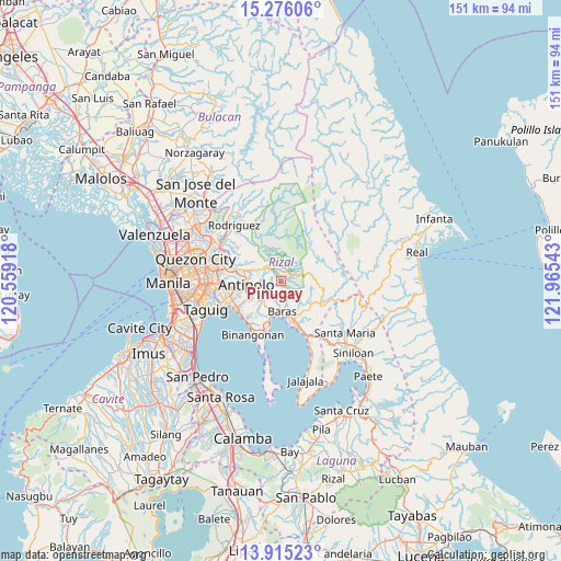
Pinugay GPS coordinates[2]
14° 35' 48.12" North, 121° 15' 44.28" East
| Map corner | latitude | longitude |
|---|---|---|
| Upper-left | 15.27606°, | 120.55918° |
| Center: | 14.5967°, | 121.2623° |
| Lower-right: | 13.91523°, | 121.96543° |
| Map W x H: | 151.3×151.3 km | = 94×94mi |
| max Lat: | 20.78733° ⇑25.5% North |
| Pinugay: | 14.5967° |
| min Lat: | ⇓74.5% South 4.65442° |
| min Long | Pinugay | max Long |
| 117.04868° | 121.2623° | 126.58417° |
| W 29.3%⇐ | ⇒70.7% E |
Elevation
Elevation of Pinugay is 199 m = 653 ft, and this is 111.1 m = 365 ft above average elevation for this country.
| Max E: |
2262 m = 7421 ft | 11.2% |
| Pinugay | 199 m 653 ft | |
| Avg. | 87.9 m = 288 ft | |
Min E: |
-2 m = -7 ft | 88.8% |
See also: Philippines elevation on elevation.city.
Geographical zone
Pinugay is located in North Torrid zone (between Equator and Tropic of Cancer). Distance of this Northern Tropic circle is 982.9 km =610.7 mi to North.| Distance of | km | miles | from Pinugay |
|---|---|---|---|
| North Pole | 8384.1 | 5209.6 | to North |
| Arctic Circle | 5778.2 | 3590.4 | to North |
| Tropic Cancer | 982.9 | 610.7 | to North |
| Equator | 1623 | 1008.5 | to South |


Nearby cities:
15 places around Pinugay: (largest is in red/bold)
• Angono
14.1 km =8.8 mi,  236°
236°
• Antipolo
15.4 km =9.6 mi,  282°
282°
• Baras
8.9 km =5.5 mi,  177°
177°
• Binangonan
16.5 km =10.3 mi,  206°
206°
• Cainta
15.2 km =9.4 mi,  262°
262°
• Cardona
12.8 km =8 mi,  196°
196°
• Daraitan
18.3 km =11.4 mi,  87°
87°
• Malanday
18.7 km =11.6 mi,  310°
310°
• Morong
9.1 km =5.7 mi, 196°
• Pililla
13.2 km =8.2 mi,  159°
159°
• Sampaloc
12.3 km =7.6 mi,  120°
120°
• San Mateo
18.7 km =11.6 mi, 307°
• Tanay
11.4 km =7.1 mi,  167°
167°
• Taytay
14.6 km =9.1 mi,  253°
253°
• Teresa
6.1 km =3.8 mi,  229°
229°
Sources, notices
• [Note1] Compared only with cities in Philippines existing in our database
• [Src1] Map data: © OpenStreetMap contributors (CC-BY-SA)
• [Src2] Other city data from geonames.org with taken over terms of usage.
• [Src3] Geographical zone / Annual Mean Temperature by Robert A. Rohde @ Wikipedia
