Malanday geodata
Malanday (Calabarzon) is a populated place; located in Philippines in Asia/Manila (GMT+8) time zone. With population of 21,901 people, there are 351 cities with bigger population in this country. Compared to other cities in Philippines, 75.2% of cities are located further ↓South; 73% of cities are located further →East and 50.3% of cities have higher elevation than Malanday. Note1


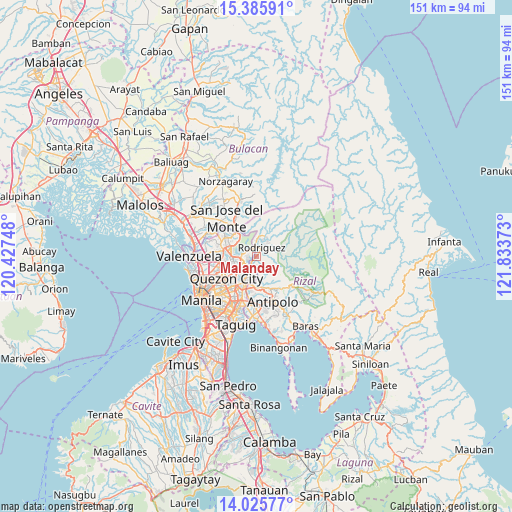
Malanday GPS coordinates[2]
14° 42' 24.84" North, 121° 7' 50.16" East
| Map corner | latitude | longitude |
|---|---|---|
| Upper-left | 15.38591°, | 120.42748° |
| Center: | 14.7069°, | 121.1306° |
| Lower-right: | 14.02577°, | 121.83373° |
| Map W x H: | 151.2×151.2 km | = 94×94mi |
| max Lat: | 20.78733° ⇑24.8% North |
| Malanday: | 14.7069° |
| min Lat: | ⇓75.2% South 4.65442° |
| min Long | Malanday | max Long |
| 117.04868° | 121.1306° | 126.58417° |
| W 27%⇐ | ⇒73% E |
Elevation
Elevation of Malanday is 23 m = 75 ft, and this is 64.9 m = 213 ft below average elevation for this country.
| Max E: |
2262 m = 7421 ft | 50.3% |
| Avg. | 87.9 m = 288 ft | |
| Malanday | 23 m = 75 ft | |
Min E: |
-2 m = -7 ft | 49.7% |
See also: Philippines elevation on elevation.city.
Geographical zone
Malanday is located in North Torrid zone (between Equator and Tropic of Cancer). Distance of this Northern Tropic circle is 970.7 km =603.2 mi to North.| Distance of | km | miles | from Malanday |
|---|---|---|---|
| North Pole | 8371.8 | 5202 | to North |
| Arctic Circle | 5765.9 | 3582.8 | to North |
| Tropic Cancer | 970.7 | 603.2 | to North |
| Equator | 1635.3 | 1016.1 | to South |


Nearby cities:
15 places around Malanday: (largest is in red/bold)
• Antipolo
9.1 km =5.7 mi,  185°
185°
• Bagong Pagasa
11.6 km =7.2 mi,  244°
244°
• Cainta
14.3 km =8.9 mi,  183°
183°
• Calumpang
10.3 km =6.4 mi,  205°
205°
• Del Monte
14.1 km =8.8 mi, 239°
• Loma de Gato
16.8 km =10.4 mi,  302°
302°
• Mandaluyong City
16.8 km =10.4 mi,  215°
215°
• Pasig City
15.3 km =9.5 mi, 209°
• Quezon City
10.7 km =6.6 mi,  232°
232°
• Rodriguez
9.5 km =5.9 mi,  51°
51°
• San Jose del Monte
15 km =9.3 mi,  322°
322°
• San Juan
15.8 km =9.8 mi, 221°
• San Mateo
1.2 km =0.7 mi, 217°
• Taytay
16.5 km =10.3 mi, 179°
• Valenzuela
17.6 km =10.9 mi,  267°
267°
Sources, notices
• [Note1] Compared only with cities in Philippines existing in our database
• [Src1] Map data: © OpenStreetMap contributors (CC-BY-SA)
• [Src2] Other city data from geonames.org with taken over terms of usage.
• [Src3] Geographical zone / Annual Mean Temperature by Robert A. Rohde @ Wikipedia
