Cainta geodata
Cainta (Calabarzon) is a seat of a third-order administrative division; located in Philippines in Asia/Manila (GMT+8) time zone. With population of 283,172 people, there are 33 cities with bigger population in this country. Compared to other cities in Philippines, 74.4% of cities are located further ↓South; 73.2% of cities are located further →East and 70.2% of cities have higher elevation than Cainta. Note1


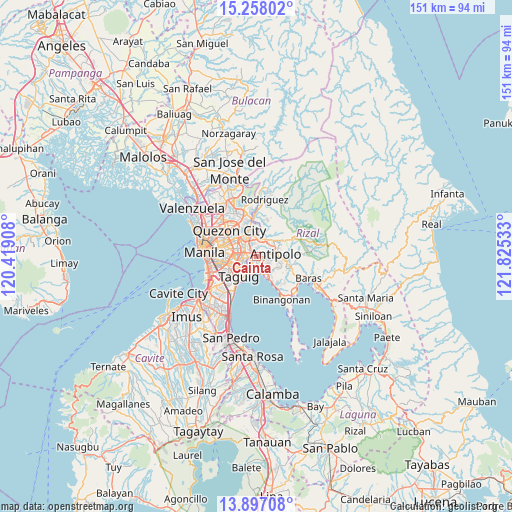
Cainta GPS coordinates[2]
14° 34' 42.96" North, 121° 7' 19.92" East
| Map corner | latitude | longitude |
|---|---|---|
| Upper-left | 15.25802°, | 120.41908° |
| Center: | 14.5786°, | 121.1222° |
| Lower-right: | 13.89708°, | 121.82533° |
| Map W x H: | 151.3×151.3 km | = 94×94mi |
| max Lat: | 20.78733° ⇑25.6% North |
| Cainta: | 14.5786° |
| min Lat: | ⇓74.4% South 4.65442° |
| min Long | Cainta | max Long |
| 117.04868° | 121.1222° | 126.58417° |
| W 26.8%⇐ | ⇒73.2% E |
Elevation
Elevation of Cainta is 12 m = 39 ft, and this is 75.9 m = 249 ft below average elevation for this country.
| Max E: |
2262 m = 7421 ft | 70.2% |
| Avg. | 87.9 m = 288 ft | |
| Cainta | 12 m = 39 ft | |
Min E: |
-2 m = -7 ft | 29.8% |
See also: Cainta elevation on elevation.city.
Geographical zone
Cainta is located in North Torrid zone (between Equator and Tropic of Cancer). Distance of this Northern Tropic circle is 984.9 km =612 mi to North.| Distance of | km | miles | from Cainta |
|---|---|---|---|
| North Pole | 8386.1 | 5210.9 | to North |
| Arctic Circle | 5780.2 | 3591.6 | to North |
| Tropic Cancer | 984.9 | 612 | to North |
| Equator | 1621 | 1007.2 | to South |


Nearby cities:
15 places around Cainta: (largest is in red/bold)
• Angono
6.7 km =4.2 mi,  149°
149°
• Antipolo
5.2 km =3.2 mi,  0°
0°
• Bagong Pagasa
13.4 km =8.3 mi,  314°
314°
• Calumpang
6 km =3.7 mi,  324°
324°
• Del Monte
13.3 km =8.3 mi,  302°
302°
• Makati City
10.1 km =6.3 mi,  251°
251°
• Mandaluyong City
8.8 km =5.5 mi,  273°
273°
• Pasig City
6.6 km =4.1 mi,  278°
278°
• Pateros
6.9 km =4.3 mi,  230°
230°
• Quezon City
10.9 km =6.8 mi, 315°
• San Juan
9.9 km =6.2 mi, 283°
• San Mateo
13.3 km =8.3 mi, 0°
• Taguig
7.6 km =4.7 mi,  217°
217°
• Taytay
2.5 km =1.6 mi, 152°
• Teresa
10.6 km =6.6 mi,  100°
100°
Sources, notices
• [Note1] Compared only with cities in Philippines existing in our database
• [Src1] Map data: © OpenStreetMap contributors (CC-BY-SA)
• [Src2] Other city data from geonames.org with taken over terms of usage.
• [Src3] Geographical zone / Annual Mean Temperature by Robert A. Rohde @ Wikipedia
