Antipolo geodata
Antipolo (Calabarzon) is a seat of a second-order administrative division; located in Philippines in Asia/Manila (GMT+8) time zone. With population of 549,543 people, there are 11 cities with bigger population in this country. Compared to other cities in Philippines, 74.7% of cities are located further ↓South; 73.2% of cities are located further →East and 50.3% of cities have higher elevation than Antipolo. Note1
Administrative division(s):
- Level 1: Calabarzon
- Level 2: Province of Rizal
- Level 3: City of Antipolo


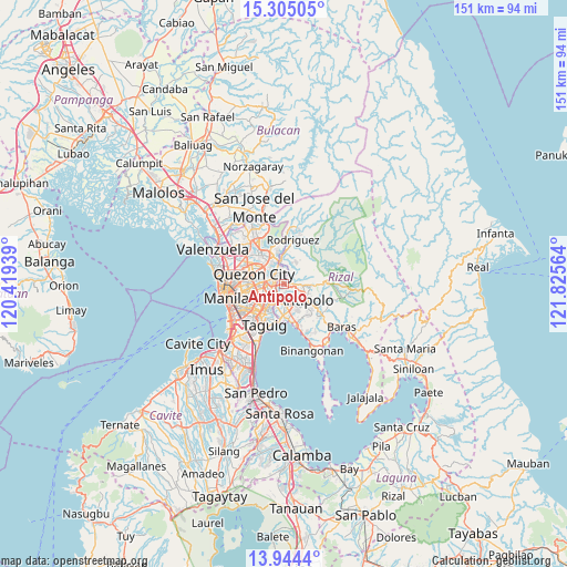
Antipolo GPS coordinates[2]
14° 37' 32.808" North, 121° 7' 21.036" East
| Map corner | latitude | longitude |
|---|---|---|
| Upper-left | 15.30505°, | 120.41939° |
| Center: | 14.62578°, | 121.12251° |
| Lower-right: | 13.9444°, | 121.82564° |
| Map W x H: | 151.3×151.3 km | = 94×94mi |
| max Lat: | 20.78733° ⇑25.3% North |
| Antipolo: | 14.62578° |
| min Lat: | ⇓74.7% South 4.65442° |
| min Long | Antipolo | max Long |
| 117.04868° | 121.12251° | 126.58417° |
| W 26.8%⇐ | ⇒73.2% E |
Elevation
Elevation of Antipolo is 23 m = 75 ft, and this is 64.9 m = 213 ft below average elevation for this country.
| Max E: |
2262 m = 7421 ft | 50.3% |
| Avg. | 87.9 m = 288 ft | |
| Antipolo | 23 m = 75 ft | |
Min E: |
-2 m = -7 ft | 49.7% |
See also: Antipolo elevation on elevation.city.
Geographical zone
Antipolo is located in North Torrid zone (between Equator and Tropic of Cancer). Distance of this Northern Tropic circle is 979.7 km =608.8 mi to North.| Distance of | km | miles | from Antipolo |
|---|---|---|---|
| North Pole | 8380.8 | 5207.6 | to North |
| Arctic Circle | 5774.9 | 3588.4 | to North |
| Tropic Cancer | 979.7 | 608.8 | to North |
| Equator | 1626.2 | 1010.5 | to South |


Nearby cities:
15 places around Antipolo: (largest is in red/bold)
• Angono
11.5 km =7.1 mi,  163°
163°
• Bagong Pagasa
10.5 km =6.5 mi,  293°
293°
• Cainta
5.2 km =3.2 mi,  180°
180°
• Calumpang
3.5 km =2.2 mi,  264°
264°
• Del Monte
11.4 km =7.1 mi,  278°
278°
• Malanday
9.1 km =5.7 mi,  5°
5°
• Mandaluyong City
10 km =6.2 mi,  241°
241°
• Pasig City
7.9 km =4.9 mi, 236°
• Pateros
11 km =6.8 mi,  209°
209°
• Quezon City
8.1 km =5 mi, 288°
• San Juan
10 km =6.2 mi,  253°
253°
• San Mateo
8.1 km =5 mi,  0°
0°
• Taguig
12.2 km =7.6 mi,  202°
202°
• Taytay
7.5 km =4.7 mi,  171°
171°
• Teresa
12.7 km =7.9 mi,  124°
124°
Sources, notices
• [Note1] Compared only with cities in Philippines existing in our database
• [Src1] Map data: © OpenStreetMap contributors (CC-BY-SA)
• [Src2] Other city data from geonames.org with taken over terms of usage.
• [Src3] Geographical zone / Annual Mean Temperature by Robert A. Rohde @ Wikipedia
