Taytay geodata
Taytay (Calabarzon) is a seat of a third-order administrative division; located in Philippines in Asia/Manila (GMT+8) time zone. With population of 231,460 people, there are 43 cities with bigger population in this country. Compared to other cities in Philippines, 74.3% of cities are located further ↓South; 72.9% of cities are located further →East and 80.7% of cities have higher elevation than Taytay. Note1


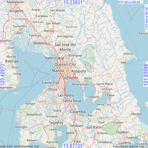
Taytay GPS coordinates[2]
14° 33' 31.788" North, 121° 7' 58.26" East
| Map corner | latitude | longitude |
|---|---|---|
| Upper-left | 15.23831°, | 120.42973° |
| Center: | 14.55883°, | 121.13285° |
| Lower-right: | 13.87725°, | 121.83598° |
| Map W x H: | 151.3×151.3 km | = 94×94mi |
| max Lat: | 20.78733° ⇑25.7% North |
| Taytay: | 14.55883° |
| min Lat: | ⇓74.3% South 4.65442° |
| min Long | Taytay | max Long |
| 117.04868° | 121.13285° | 126.58417° |
| W 27.1%⇐ | ⇒72.9% E |
Elevation
Elevation of Taytay is 9 m = 30 ft, and this is 78.9 m = 259 ft below average elevation for this country.
| Max E: |
2262 m = 7421 ft | 80.7% |
| Avg. | 87.9 m = 288 ft | |
| Taytay | 9 m = 30 ft | |
Min E: |
-2 m = -7 ft | 19.3% |
See also: Taytay elevation on elevation.city.
Geographical zone
Taytay is located in North Torrid zone (between Equator and Tropic of Cancer). Distance of this Northern Tropic circle is 987.1 km =613.4 mi to North.| Distance of | km | miles | from Taytay |
|---|---|---|---|
| North Pole | 8388.3 | 5212.2 | to North |
| Arctic Circle | 5782.4 | 3593 | to North |
| Tropic Cancer | 987.1 | 613.4 | to North |
| Equator | 1618.8 | 1005.9 | to South |


Nearby cities:
15 places around Taytay: (largest is in red/bold)
• Angono
4.2 km =2.6 mi,  148°
148°
• Antipolo
7.5 km =4.7 mi,  351°
351°
• Binangonan
12.3 km =7.6 mi, 148°
• Cainta
2.5 km =1.6 mi,  332°
332°
• Calumpang
8.5 km =5.3 mi, 326°
• Cardona
13 km =8.1 mi,  128°
128°
• Makati City
10.8 km =6.7 mi,  264°
264°
• Mandaluyong City
10.3 km =6.4 mi,  285°
285°
• Morong
12.2 km =7.6 mi,  111°
111°
• Pasig City
8.3 km =5.2 mi, 292°
• Pateros
6.8 km =4.2 mi,  251°
251°
• Quezon City
13.3 km =8.3 mi,  318°
318°
• San Juan
11.6 km =7.2 mi, 293°
• Taguig
6.9 km =4.3 mi,  236°
236°
• Teresa
9.3 km =5.8 mi,  88°
88°
Sources, notices
• [Note1] Compared only with cities in Philippines existing in our database
• [Src1] Map data: © OpenStreetMap contributors (CC-BY-SA)
• [Src2] Other city data from geonames.org with taken over terms of usage.
• [Src3] Geographical zone / Annual Mean Temperature by Robert A. Rohde @ Wikipedia
