Taguig geodata
Taguig (Metro Manila) is a seat of a third-order administrative division; located in Philippines in Asia/Manila (GMT+8) time zone. With population of 644,473 people, there are 8 cities with bigger population in this country. Compared to other cities in Philippines, 74.2% of cities are located further ↓South; 74.4% of cities are located further →East and 95.5% of cities have higher elevation than Taguig. Note1
Administrative division(s):
- Level 1: Metro Manila
- Level 2: Southern Manila District
- Level 3: Taguig City


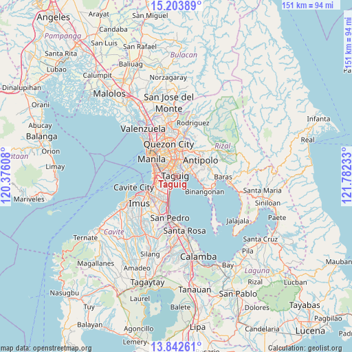
Taguig GPS coordinates[2]
14° 31' 27.48" North, 121° 4' 45.12" East
| Map corner | latitude | longitude |
|---|---|---|
| Upper-left | 15.20389°, | 120.37608° |
| Center: | 14.5243°, | 121.0792° |
| Lower-right: | 13.84261°, | 121.78233° |
| Map W x H: | 151.4×151.4 km | = 94.1×94.1mi |
| max Lat: | 20.78733° ⇑25.8% North |
| Taguig: | 14.5243° |
| min Lat: | ⇓74.2% South 4.65442° |
| min Long | Taguig | max Long |
| 117.04868° | 121.0792° | 126.58417° |
| W 25.6%⇐ | ⇒74.4% E |
Elevation
Elevation of Taguig is 5 m = 16 ft, and this is 82.9 m = 272 ft below average elevation for this country.
| Max E: |
2262 m = 7421 ft | 95.5% |
| Avg. | 87.9 m = 288 ft | |
| Taguig | 5 m = 16 ft | |
Min E: |
-2 m = -7 ft | 4.5% |
See also: Taguig elevation on elevation.city.
Geographical zone
Taguig is located in North Torrid zone (between Equator and Tropic of Cancer). Distance of this Northern Tropic circle is 991 km =615.8 mi to North.| Distance of | km | miles | from Taguig |
|---|---|---|---|
| North Pole | 8392.1 | 5214.6 | to North |
| Arctic Circle | 5786.2 | 3595.4 | to North |
| Tropic Cancer | 991 | 615.8 | to North |
| Equator | 1615 | 1003.5 | to South |


Nearby cities:
15 places around Taguig: (largest is in red/bold)
• Angono
8 km =5 mi,  88°
88°
• Antipolo
12.2 km =7.6 mi,  22°
22°
• Cainta
7.6 km =4.7 mi,  37°
37°
• Calumpang
11 km =6.8 mi,  5°
5°
• Las Piñas
13.2 km =8.2 mi,  231°
231°
• Makati City
5.8 km =3.6 mi,  299°
299°
• Mandaluyong City
7.7 km =4.8 mi,  327°
327°
• Manila
13.7 km =8.5 mi,  310°
310°
• Pasay
8.5 km =5.3 mi,  279°
279°
• Pasig City
7.2 km =4.5 mi,  344°
344°
• Pateros
1.8 km =1.1 mi, 336°
• Quiapo
13.3 km =8.3 mi, 309°
• Sambayanihan People's Village
11.6 km =7.2 mi, 228°
• San Juan
9.8 km =6.1 mi, 329°
• Taytay
6.9 km =4.3 mi,  56°
56°
Sources, notices
• [Note1] Compared only with cities in Philippines existing in our database
• [Src1] Map data: © OpenStreetMap contributors (CC-BY-SA)
• [Src2] Other city data from geonames.org with taken over terms of usage.
• [Src3] Geographical zone / Annual Mean Temperature by Robert A. Rohde @ Wikipedia
