Manikling geodata
Manikling (Davao) is a populated place; located in Philippines in Asia/Manila (GMT+8) time zone. With population of 2,444 people, there are 3391 cities with bigger population in this country. Compared to other cities in Philippines, 92.7% of cities are located further ↑North; 98.1% of cities are located further ←West and 53.1% of cities have higher elevation than Manikling. Note1


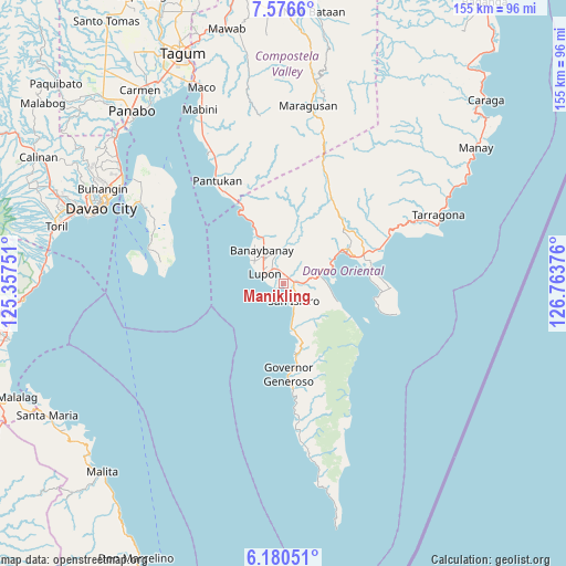
Manikling GPS coordinates[2]
6° 52' 44.652" North, 126° 3' 38.268" East
| Map corner | latitude | longitude |
|---|---|---|
| Upper-left | 7.5766°, | 125.35751° |
| Center: | 6.87907°, | 126.06063° |
| Lower-right: | 6.18051°, | 126.76376° |
| Map W x H: | 155.2×155.2 km | = 96.4×96.4mi |
| max Lat: | 20.78733° ⇑92.7% North |
| Manikling: | 6.87907° |
| min Lat: | ⇓7.3% South 4.65442° |
| min Long | Manikling | max Long |
| 117.04868° | 126.06063° | 126.58417° |
| W 98.1%⇐ | ⇒1.9% E |
Elevation
Elevation of Manikling is 21 m = 69 ft, and this is 66.9 m = 219 ft below average elevation for this country.
| Max E: |
2262 m = 7421 ft | 53.1% |
| Avg. | 87.9 m = 288 ft | |
| Manikling | 21 m = 69 ft | |
Min E: |
-2 m = -7 ft | 46.9% |
See also: Philippines elevation on elevation.city.
Geographical zone
Manikling is located in North Torrid zone (between Equator and Tropic of Cancer). Distance of Equator is 764.9 km =475.3 mi to South.| Distance of | km | miles | from Manikling |
|---|---|---|---|
| North Pole | 9242.2 | 5742.8 | to North |
| Arctic Circle | 6636.3 | 4123.6 | to North |
| Tropic Cancer | 1841 | 1143.9 | to North |
| Equator | 764.9 | 475.3 | to South |


Nearby cities:
15 places around Manikling: (largest is in red/bold)
• Banaybanay
10.4 km =6.5 mi,  332°
332°
• Baon
9.8 km =6.1 mi,  162°
162°
• Batobato
6.5 km =4 mi, 156°
• Bitaogan
12.4 km =7.7 mi,  171°
171°
• Davan
11 km =6.8 mi,  68°
68°
• Ilangay
3.9 km =2.4 mi,  342°
342°
• La Union
19.7 km =12.2 mi, 171°
• Linao
17.1 km =10.6 mi, 333°
• Lupon
6 km =3.7 mi,  290°
290°
• Mati
19.2 km =11.9 mi,  63°
63°
• Panikian
15.2 km =9.4 mi, 344°
• Sigaboy
25 km =15.5 mi,  176°
176°
• Talisay
18.2 km =11.3 mi, 166°
• Tamisan
26.5 km =16.5 mi,  98°
98°
• Tombongon
25.5 km =15.8 mi, 330°
Sources, notices
• [Note1] Compared only with cities in Philippines existing in our database
• [Src1] Map data: © OpenStreetMap contributors (CC-BY-SA)
• [Src2] Other city data from geonames.org with taken over terms of usage.
• [Src3] Geographical zone / Annual Mean Temperature by Robert A. Rohde @ Wikipedia
