Mati geodata
Mati (Davao) is a seat of a second-order administrative division; located in Philippines in Asia/Manila (GMT+8) time zone. With population of 105,908 people, there are 87 cities with bigger population in this country. Compared to other cities in Philippines, 92.1% of cities are located further ↑North; 99.1% of cities are located further ←West and 53.1% of cities have higher elevation than Mati. Note1
Administrative division(s):
- Level 1: Davao
- Level 2: Province of Davao Oriental
- Level 3: City of Mati


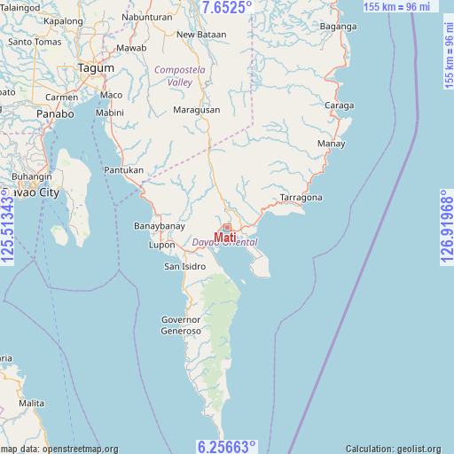
Mati GPS coordinates[2]
6° 57' 18.288" North, 126° 12' 59.58" East
| Map corner | latitude | longitude |
|---|---|---|
| Upper-left | 7.6525°, | 125.51343° |
| Center: | 6.95508°, | 126.21655° |
| Lower-right: | 6.25663°, | 126.91968° |
| Map W x H: | 155.2×155.2 km | = 96.4×96.4mi |
| max Lat: | 20.78733° ⇑92.1% North |
| Mati: | 6.95508° |
| min Lat: | ⇓7.9% South 4.65442° |
| min Long | Mati | max Long |
| 117.04868° | 126.21655° | 126.58417° |
| W 99.1%⇐ | ⇒0.90000000000001% E |
Elevation
Elevation of Mati is 21 m = 69 ft, and this is 66.9 m = 219 ft below average elevation for this country.
| Max E: |
2262 m = 7421 ft | 53.1% |
| Avg. | 87.9 m = 288 ft | |
| Mati | 21 m = 69 ft | |
Min E: |
-2 m = -7 ft | 46.9% |
See also: Mati elevation on elevation.city.
Geographical zone
Mati is located in North Torrid zone (between Equator and Tropic of Cancer). Distance of Equator is 773.3 km =480.5 mi to South.| Distance of | km | miles | from Mati |
|---|---|---|---|
| North Pole | 9233.7 | 5737.6 | to North |
| Arctic Circle | 6627.8 | 4118.3 | to North |
| Tropic Cancer | 1832.6 | 1138.7 | to North |
| Equator | 773.3 | 480.5 | to South |


Nearby cities:
15 places around Mati: (largest is in red/bold)
• Banaybanay
22 km =13.7 mi,  272°
272°
• Baon
22.7 km =14.1 mi,  218°
218°
• Batobato
20.5 km =12.7 mi,  225°
225°
• Bitaogan
25.8 km =16 mi, 216°
• Bobon
15.7 km =9.8 mi,  128°
128°
• Davan
8.3 km =5.2 mi,  237°
237°
• Ilangay
19 km =11.8 mi,  255°
255°
• Limot
11.3 km =7 mi,  33°
33°
• Linao
25.7 km =16 mi,  285°
285°
• Lukatan
23.4 km =14.5 mi,  74°
74°
• Lupon
23.7 km =14.7 mi,  254°
254°
• Manikling
19.2 km =11.9 mi, 243°
• Mayo
13.8 km =8.6 mi, 67°
• Panikian
22.1 km =13.7 mi, 286°
• Tamisan
15.3 km =9.5 mi,  143°
143°
Sources, notices
• [Note1] Compared only with cities in Philippines existing in our database
• [Src1] Map data: © OpenStreetMap contributors (CC-BY-SA)
• [Src2] Other city data from geonames.org with taken over terms of usage.
• [Src3] Geographical zone / Annual Mean Temperature by Robert A. Rohde @ Wikipedia
