Katipunan geodata
Katipunan (Davao) is a populated place; located in Philippines in Asia/Manila (GMT+8) time zone. With population of 2,468 people, there are 3349 cities with bigger population in this country. Compared to other cities in Philippines, 88.4% of cities are located further ↑North; 94.7% of cities are located further ←West and 73.4% of cities have lower elevation than Katipunan. Note1
Administrative division(s):
- Level 1: Davao
- Level 2: Province of Davao del Norte
- Level 3: City of Panabo


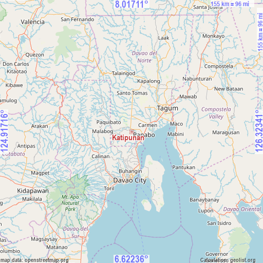
Katipunan GPS coordinates[2]
7° 19' 13.008" North, 125° 37' 13.008" East
| Map corner | latitude | longitude |
|---|---|---|
| Upper-left | 8.01711°, | 124.91716° |
| Center: | 7.32028°, | 125.62028° |
| Lower-right: | 6.62236°, | 126.32341° |
| Map W x H: | 155.1×155.1 km | = 96.4×96.4mi |
| max Lat: | 20.78733° ⇑88.4% North |
| Katipunan: | 7.32028° |
| min Lat: | ⇓11.6% South 4.65442° |
| min Long | Katipunan | max Long |
| 117.04868° | 125.62028° | 126.58417° |
| W 94.7%⇐ | ⇒5.3% E |
Elevation
Elevation of Katipunan is 62 m = 203 ft, and this is 25.9 m = 85 ft below average elevation for this country.
| Max E: |
2262 m = 7421 ft | 26.6% |
| Avg. | 87.9 m = 288 ft | |
| Katipunan | 62 m = 203 ft | |
Min E: |
-2 m = -7 ft | 73.4% |
See also: Philippines elevation on elevation.city.
Geographical zone
Katipunan is located in North Torrid zone (between Equator and Tropic of Cancer). Distance of Equator is 813.9 km =505.7 mi to South.| Distance of | km | miles | from Katipunan |
|---|---|---|---|
| North Pole | 9193.1 | 5712.3 | to North |
| Arctic Circle | 6587.2 | 4093.1 | to North |
| Tropic Cancer | 1792 | 1113.5 | to North |
| Equator | 813.9 | 505.7 | to South |


Nearby cities:
15 places around Katipunan: (largest is in red/bold)
• Alejal
8.3 km =5.2 mi,  31°
31°
• Carmen
10.5 km =6.5 mi,  64°
64°
• La Paz
12.5 km =7.8 mi,  92°
92°
• Lasang
7.7 km =4.8 mi,  140°
140°
• Mabuhay
8.2 km =5.1 mi,  280°
280°
• Maduao
3 km =1.9 mi,  168°
168°
• Magsaysay
8.6 km =5.3 mi,  10°
10°
• Mahayag
11.5 km =7.1 mi,  180°
180°
• Manaloal
6.7 km =4.2 mi,  40°
40°
• Manay
5.5 km =3.4 mi,  295°
295°
• Nanyo
2.4 km =1.5 mi,  53°
53°
• Panabo
7.2 km =4.5 mi,  100°
100°
• Santo Niño
9.4 km =5.8 mi,  84°
84°
• Tubod
6.3 km =3.9 mi, 25°
• Tuganay
12.6 km =7.8 mi, 64°
Sources, notices
• [Note1] Compared only with cities in Philippines existing in our database
• [Src1] Map data: © OpenStreetMap contributors (CC-BY-SA)
• [Src2] Other city data from geonames.org with taken over terms of usage.
• [Src3] Geographical zone / Annual Mean Temperature by Robert A. Rohde @ Wikipedia
