Lim-oo geodata
Lim-oo (Eastern Visayas) is a populated place; located in Philippines in Asia/Manila (GMT+8) time zone. With population of 2,137 people, there are 4017 cities with bigger population in this country. Compared to other cities in Philippines, 55.1% of cities are located further ↑North; 81.3% of cities are located further ←West and 93% of cities have lower elevation than Lim-oo. Note1


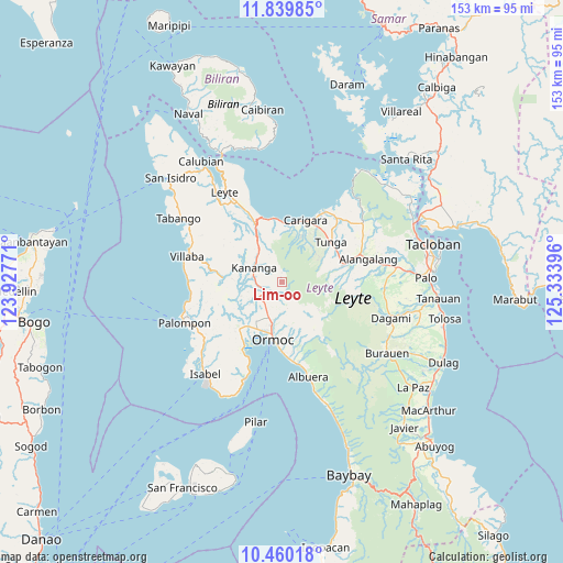
Lim-oo GPS coordinates[2]
11° 9' 2.988" North, 124° 37' 50.988" East
| Map corner | latitude | longitude |
|---|---|---|
| Upper-left | 11.83985°, | 123.92771° |
| Center: | 11.15083°, | 124.63083° |
| Lower-right: | 10.46018°, | 125.33396° |
| Map W x H: | 153.4×153.4 km | = 95.3×95.3mi |
| max Lat: | 20.78733° ⇑55.1% North |
| Lim-oo: | 11.15083° |
| min Lat: | ⇓44.9% South 4.65442° |
| min Long | Lim-oo | max Long |
| 117.04868° | 124.63083° | 126.58417° |
| W 81.3%⇐ | ⇒18.7% E |
Elevation
Elevation of Lim-oo is 327 m = 1073 ft, and this is 239.1 m = 784 ft above average elevation for this country.
| Max E: |
2262 m = 7421 ft | 7% |
| Lim-oo | 327 m 1073 ft | |
| Avg. | 87.9 m = 288 ft | |
Min E: |
-2 m = -7 ft | 93% |
See also: Philippines elevation on elevation.city.
Geographical zone
Lim-oo is located in North Torrid zone (between Equator and Tropic of Cancer). Distance of Equator is 1239.9 km =770.4 mi to South.| Distance of | km | miles | from Lim-oo |
|---|---|---|---|
| North Pole | 8767.2 | 5447.7 | to North |
| Arctic Circle | 6161.3 | 3828.5 | to North |
| Tropic Cancer | 1366.1 | 848.9 | to North |
| Equator | 1239.9 | 770.4 | to South |


Nearby cities:
15 places around Lim-oo: (largest is in red/bold)
• Balagtas
12.3 km =7.6 mi,  260°
260°
• Canhandugan
16.3 km =10.1 mi,  96°
96°
• Capoocan
15.9 km =9.9 mi,  4°
4°
• Dolores
10.1 km =6.3 mi,  190°
190°
• Kananya
8.7 km =5.4 mi,  297°
297°
• Libertad
14.4 km =8.9 mi,  208°
208°
• Liloan
14.7 km =9.1 mi,  216°
216°
• Malilinao
15 km =9.3 mi,  250°
250°
• Masarayao
6.9 km =4.3 mi, 192°
• Naghalin
7 km =4.3 mi,  265°
265°
• Rizal
6.3 km =3.9 mi, 296°
• San Vicente
8 km =5 mi,  243°
243°
• Santo Niño
12.3 km =7.6 mi, 217°
• Tugbong
15.3 km =9.5 mi, 192°
• Valencia
7.9 km =4.9 mi,  233°
233°
Sources, notices
• [Note1] Compared only with cities in Philippines existing in our database
• [Src1] Map data: © OpenStreetMap contributors (CC-BY-SA)
• [Src2] Other city data from geonames.org with taken over terms of usage.
• [Src3] Geographical zone / Annual Mean Temperature by Robert A. Rohde @ Wikipedia
