Pamatawan geodata
Pamatawan (Central Luzon) is a populated place; located in Philippines in Asia/Manila (GMT+8) time zone. With population of 2,849 people, there are 2704 cities with bigger population in this country. Compared to other cities in Philippines, 76.7% of cities are located further ↓South; 96% of cities are located further →East and 70% of cities have lower elevation than Pamatawan. Note1
Administrative division(s):
- Level 1: Central Luzon
- Level 2: Province of Zambales
- Level 3: Castillejos


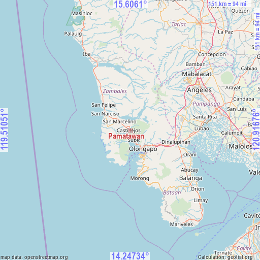
Pamatawan GPS coordinates[2]
14° 55' 40.044" North, 120° 12' 49.068" East
| Map corner | latitude | longitude |
|---|---|---|
| Upper-left | 15.6061°, | 119.51051° |
| Center: | 14.92779°, | 120.21363° |
| Lower-right: | 14.24734°, | 120.91676° |
| Map W x H: | 151.1×151.1 km | = 93.9×93.9mi |
| max Lat: | 20.78733° ⇑23.3% North |
| Pamatawan: | 14.92779° |
| min Lat: | ⇓76.7% South 4.65442° |
| min Long | Pamatawan | max Long |
| 117.04868° | 120.21363° | 126.58417° |
| W 4%⇐ | ⇒96% E |
Elevation
Elevation of Pamatawan is 52 m = 171 ft, and this is 35.9 m = 118 ft below average elevation for this country.
| Max E: |
2262 m = 7421 ft | 30% |
| Avg. | 87.9 m = 288 ft | |
| Pamatawan | 52 m = 171 ft | |
Min E: |
-2 m = -7 ft | 70% |
See also: Philippines elevation on elevation.city.
Geographical zone
Pamatawan is located in North Torrid zone (between Equator and Tropic of Cancer). Distance of this Northern Tropic circle is 946.1 km =587.9 mi to North.| Distance of | km | miles | from Pamatawan |
|---|---|---|---|
| North Pole | 8347.2 | 5186.7 | to North |
| Arctic Circle | 5741.4 | 3567.5 | to North |
| Tropic Cancer | 946.1 | 587.9 | to North |
| Equator | 1659.8 | 1031.4 | to South |


Nearby cities:
15 places around Pamatawan: (largest is in red/bold)
• Beddeng
14.9 km =9.3 mi,  291°
291°
• Castillejos
1.8 km =1.1 mi, 290°
• Dinalupihan
26.2 km =16.3 mi,  102°
102°
• Mabayo
22.9 km =14.2 mi,  162°
162°
• Olongapo
13.2 km =8.2 mi,  145°
145°
• Poblacion, San Felipe
21.5 km =13.4 mi,  314°
314°
• San Agustin
6.9 km =4.3 mi,  275°
275°
• San Antonio
13.8 km =8.6 mi, 278°
• San Benito
24.4 km =15.2 mi,  110°
110°
• San Marcelino
7.9 km =4.9 mi, 310°
• San Narciso
17.3 km =10.7 mi,  303°
303°
• San Nicolas
14.9 km =9.3 mi, 279°
• Santa Fe
9.2 km =5.7 mi,  357°
357°
• Subic
5.8 km =3.6 mi, 160°
• Subic Bay Freeport Zone
17 km =10.6 mi, 155°
Sources, notices
• [Note1] Compared only with cities in Philippines existing in our database
• [Src1] Map data: © OpenStreetMap contributors (CC-BY-SA)
• [Src2] Other city data from geonames.org with taken over terms of usage.
• [Src3] Geographical zone / Annual Mean Temperature by Robert A. Rohde @ Wikipedia
