Mantang geodata
Mantang (Eastern Visayas) is a populated place; located in Philippines in Asia/Manila (GMT+8) time zone. With population of 2,081 people, there are 4101 cities with bigger population in this country. Compared to other cities in Philippines, 51.3% of cities are located further ↓South; 92.5% of cities are located further ←West and 85.4% of cities have higher elevation than Mantang. Note1
Administrative division(s):
- Level 1: Eastern Visayas
- Level 2: Province of Eastern Samar
- Level 3: Taft


Mantang GPS coordinates[2]
11° 52' 12" North, 125° 25' 41.988" East
| Map corner | latitude | longitude |
|---|---|---|
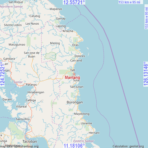
| Upper-left | 12.55721°, | 124.72521° |
| Center: | 11.87°, | 125.42833° |
| Lower-right: | 11.18106°, | 126.13146° |
| Map W x H: | 153×153 km | = 95.1×95.1mi |
| max Lat: | 20.78733° ⇑48.7% North |
| Mantang: | 11.87° |
| min Lat: | ⇓51.3% South 4.65442° |
| min Long | Mantang | max Long |
| 117.04868° | 125.42833° | 126.58417° |
| W 92.5%⇐ | ⇒7.5% E |
Elevation
Elevation of Mantang is 8 m = 26 ft, and this is 79.9 m = 262 ft below average elevation for this country.
| Max E: |
2262 m = 7421 ft | 85.4% |
| Avg. | 87.9 m = 288 ft | |
| Mantang | 8 m = 26 ft | |
Min E: |
-2 m = -7 ft | 14.6% |
See also: Philippines elevation on elevation.city.
Geographical zone
Mantang is located in North Torrid zone (between Equator and Tropic of Cancer). Distance of this Northern Tropic circle is 1286.1 km =799.1 mi to North.| Distance of | km | miles | from Mantang |
|---|---|---|---|
| North Pole | 8687.2 | 5398 | to North |
| Arctic Circle | 6081.4 | 3778.8 | to North |
| Tropic Cancer | 1286.1 | 799.1 | to North |
| Equator | 1319.8 | 820.1 | to South |


Nearby cities:
15 places around Mantang: (largest is in red/bold)
• Balud
28.2 km =17.5 mi,  178°
178°
• Borongan
29.1 km =18.1 mi, 179°
• Can-Avid
14.1 km =8.8 mi,  8°
8°
• Dao
25.6 km =15.9 mi,  2°
2°
• Dapdap
22.3 km =13.9 mi,  16°
16°
• Dolores
19.5 km =12.1 mi, 17°
• Lalauigan
31.5 km =19.6 mi,  171°
171°
• Maypangdan
24.4 km =15.2 mi, 174°
• Nena
11.6 km =7.2 mi,  185°
185°
• Oras
30.1 km =18.7 mi, 2°
• Paranas
34.1 km =21.2 mi,  266°
266°
• San Eduardo
33.2 km =20.6 mi, 4°
• San Julian
13.3 km =8.3 mi, 166°
• Sulat
7.2 km =4.5 mi,  156°
156°
• Taft
3.6 km =2.2 mi,  343°
343°
Sources, notices
• [Note1] Compared only with cities in Philippines existing in our database
• [Src1] Map data: © OpenStreetMap contributors (CC-BY-SA)
• [Src2] Other city data from geonames.org with taken over terms of usage.
• [Src3] Geographical zone / Annual Mean Temperature by Robert A. Rohde @ Wikipedia
