Masapang geodata
Masapang (Calabarzon) is a populated place; located in Philippines in Asia/Manila (GMT+8) time zone. With population of 4,580 people, there are 1454 cities with bigger population in this country. Compared to other cities in Philippines, 71.9% of cities are located further ↓South; 69.5% of cities are located further →East and 65.1% of cities have higher elevation than Masapang. Note1


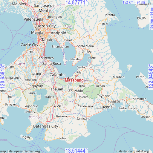
Masapang GPS coordinates[2]
14° 11' 49.56" North, 121° 20' 32.28" East
| Map corner | latitude | longitude |
|---|---|---|
| Upper-left | 14.87771°, | 120.63918° |
| Center: | 14.1971°, | 121.3423° |
| Lower-right: | 13.51444°, | 122.04543° |
| Map W x H: | 151.6×151.6 km | = 94.2×94.2mi |
| max Lat: | 20.78733° ⇑28.1% North |
| Masapang: | 14.1971° |
| min Lat: | ⇓71.9% South 4.65442° |
| min Long | Masapang | max Long |
| 117.04868° | 121.3423° | 126.58417° |
| W 30.5%⇐ | ⇒69.5% E |
Elevation
Elevation of Masapang is 14 m = 46 ft, and this is 73.9 m = 242 ft below average elevation for this country.
| Max E: |
2262 m = 7421 ft | 65.1% |
| Avg. | 87.9 m = 288 ft | |
| Masapang | 14 m = 46 ft | |
Min E: |
-2 m = -7 ft | 34.9% |
See also: Philippines elevation on elevation.city.
Geographical zone
Masapang is located in North Torrid zone (between Equator and Tropic of Cancer). Distance of this Northern Tropic circle is 1027.3 km =638.3 mi to North.| Distance of | km | miles | from Masapang |
|---|---|---|---|
| North Pole | 8428.5 | 5237.2 | to North |
| Arctic Circle | 5822.6 | 3618 | to North |
| Tropic Cancer | 1027.3 | 638.3 | to North |
| Equator | 1578.6 | 980.9 | to South |


Nearby cities:
15 places around Masapang: (largest is in red/bold)
• Bay
6.3 km =3.9 mi,  256°
256°
• Calauan
6 km =3.7 mi,  209°
209°
• Calumpang
6.4 km =4 mi,  90°
90°
• Cigaras
10 km =6.2 mi,  70°
70°
• Dayap
2.1 km =1.3 mi, 207°
• Halayhayin
7.1 km =4.4 mi,  97°
97°
• Hanggan
4.6 km =2.9 mi, 258°
• Magdalena
9.4 km =5.8 mi, 88°
• Masaya
8.2 km =5.1 mi,  232°
232°
• Pila
4.6 km =2.9 mi,  31°
31°
• San Isidro
6.2 km =3.9 mi,  78°
78°
• San Miguel
3.4 km =2.1 mi, 82°
• Santa Catalina
8.4 km =5.2 mi,  180°
180°
• Taytay
10.4 km =6.5 mi,  140°
140°
• Victoria
3.7 km =2.3 mi,  337°
337°
Sources, notices
• [Note1] Compared only with cities in Philippines existing in our database
• [Src1] Map data: © OpenStreetMap contributors (CC-BY-SA)
• [Src2] Other city data from geonames.org with taken over terms of usage.
• [Src3] Geographical zone / Annual Mean Temperature by Robert A. Rohde @ Wikipedia
