Bay geodata
Bay (Calabarzon) is a seat of a third-order administrative division; located in Philippines in Asia/Manila (GMT+8) time zone. With population of 33,547 people, there are 255 cities with bigger population in this country. Compared to other cities in Philippines, 71.5% of cities are located further ↓South; 70.4% of cities are located further →East and 73.2% of cities have higher elevation than Bay. Note1


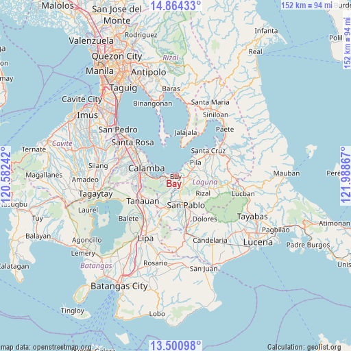
Bay GPS coordinates[2]
14° 11' 1.248" North, 121° 17' 7.944" East
| Map corner | latitude | longitude |
|---|---|---|
| Upper-left | 14.86433°, | 120.58242° |
| Center: | 14.18368°, | 121.28554° |
| Lower-right: | 13.50098°, | 121.98867° |
| Map W x H: | 151.6×151.6 km | = 94.2×94.2mi |
| max Lat: | 20.78733° ⇑28.5% North |
| Bay: | 14.18368° |
| min Lat: | ⇓71.5% South 4.65442° |
| min Long | Bay | max Long |
| 117.04868° | 121.28554° | 126.58417° |
| W 29.6%⇐ | ⇒70.4% E |
Elevation
Elevation of Bay is 11 m = 36 ft, and this is 76.9 m = 252 ft below average elevation for this country.
| Max E: |
2262 m = 7421 ft | 73.2% |
| Avg. | 87.9 m = 288 ft | |
| Bay | 11 m = 36 ft | |
Min E: |
-2 m = -7 ft | 26.8% |
See also: Philippines elevation on elevation.city.
Geographical zone
Bay is located in North Torrid zone (between Equator and Tropic of Cancer). Distance of this Northern Tropic circle is 1028.8 km =639.3 mi to North.| Distance of | km | miles | from Bay |
|---|---|---|---|
| North Pole | 8430 | 5238.2 | to North |
| Arctic Circle | 5824.1 | 3618.9 | to North |
| Tropic Cancer | 1028.8 | 639.3 | to North |
| Equator | 1577.1 | 980 | to South |


Nearby cities:
15 places around Bay: (largest is in red/bold)
• Bitin
10.1 km =6.3 mi,  222°
222°
• Calauan
4.9 km =3 mi,  139°
139°
• Calumpang
12.6 km =7.8 mi,  83°
83°
• Dayap
5.2 km =3.2 mi,  94°
94°
• Hanggan
1.7 km =1.1 mi,  70°
70°
• Los Baños
4.9 km =3 mi,  252°
252°
• Masapang
6.3 km =3.9 mi, 76°
• Masaya
3.6 km =2.2 mi,  186°
186°
• Pila
10.1 km =6.3 mi,  57°
57°
• Punta
12.2 km =7.6 mi,  11°
11°
• San Isidro
12.5 km =7.8 mi, 77°
• San Miguel
9.7 km =6 mi, 78°
• Santa Catalina
9.2 km =5.7 mi, 138°
• Santa Cruz
7.5 km =4.7 mi,  181°
181°
• Victoria
6.8 km =4.2 mi,  43°
43°
Sources, notices
• [Note1] Compared only with cities in Philippines existing in our database
• [Src1] Map data: © OpenStreetMap contributors (CC-BY-SA)
• [Src2] Other city data from geonames.org with taken over terms of usage.
• [Src3] Geographical zone / Annual Mean Temperature by Robert A. Rohde @ Wikipedia
