Mangili geodata
Mangili (Davao) is a populated place; located in Philippines in Asia/Manila (GMT+8) time zone. With population of 3,020 people, there are 2500 cities with bigger population in this country. Compared to other cities in Philippines, 97.9% of cities are located further ↑North; 95.5% of cities are located further ←West and 73.8% of cities have lower elevation than Mangili. Note1
Administrative division(s):
- Level 1: Davao
- Level 2: Davao Occidental
- Level 3: Jose Abad Santos (Trinidad)


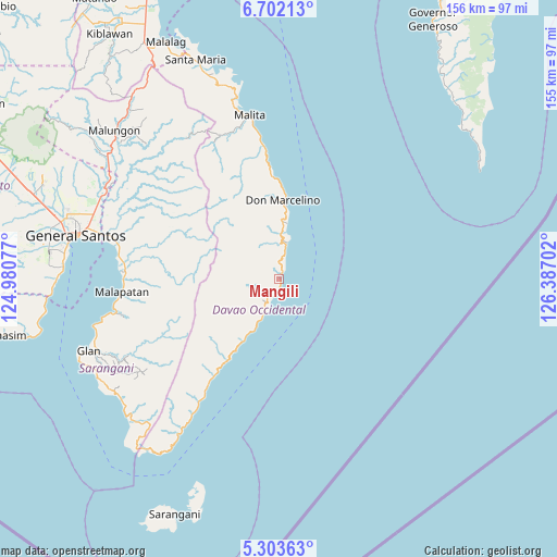
Mangili GPS coordinates[2]
6° 0' 11.988" North, 125° 41' 2.004" East
| Map corner | latitude | longitude |
|---|---|---|
| Upper-left | 6.70213°, | 124.98077° |
| Center: | 6.00333°, | 125.68389° |
| Lower-right: | 5.30363°, | 126.38702° |
| Map W x H: | 155.5×155.5 km | = 96.6×96.6mi |
| max Lat: | 20.78733° ⇑97.9% North |
| Mangili: | 6.00333° |
| min Lat: | ⇓2.1% South 4.65442° |
| min Long | Mangili | max Long |
| 117.04868° | 125.68389° | 126.58417° |
| W 95.5%⇐ | ⇒4.5% E |
Elevation
Elevation of Mangili is 64 m = 210 ft, and this is 23.9 m = 78 ft below average elevation for this country.
| Max E: |
2262 m = 7421 ft | 26.2% |
| Avg. | 87.9 m = 288 ft | |
| Mangili | 64 m = 210 ft | |
Min E: |
-2 m = -7 ft | 73.8% |
See also: Philippines elevation on elevation.city.
Geographical zone
Mangili is located in North Torrid zone (between Equator and Tropic of Cancer). Distance of Equator is 667.5 km =414.8 mi to South.| Distance of | km | miles | from Mangili |
|---|---|---|---|
| North Pole | 9339.6 | 5803.4 | to North |
| Arctic Circle | 6733.7 | 4184.1 | to North |
| Tropic Cancer | 1938.4 | 1204.5 | to North |
| Equator | 667.5 | 414.8 | to South |


Nearby cities:
15 places around Mangili: (largest is in red/bold)
• Bolila
42.8 km =26.6 mi,  343°
343°
• Caburan
10.6 km =6.6 mi,  206°
206°
• Culaman
5.5 km =3.4 mi, 210°
• Kalbay
37.3 km =23.2 mi, 213°
• Kalian
13.4 km =8.3 mi,  7°
7°
• Kinangan
34.9 km =21.7 mi, 341°
• Kiupo
44.2 km =27.5 mi,  245°
245°
• Lais
36.9 km =22.9 mi,  353°
353°
• Lamitan
9.5 km =5.9 mi, 12°
• Lapuan
15.8 km =9.8 mi, 6°
• Lun Pequeño
44.4 km =27.6 mi,  274°
274°
• Malapatan
43.8 km =27.2 mi, 265°
• Suyan
33.6 km =20.9 mi,  280°
280°
• Talagutong
29.1 km =18.1 mi,  356°
356°
• Tuyan
44.3 km =27.5 mi, 269°
Sources, notices
• [Note1] Compared only with cities in Philippines existing in our database
• [Src1] Map data: © OpenStreetMap contributors (CC-BY-SA)
• [Src2] Other city data from geonames.org with taken over terms of usage.
• [Src3] Geographical zone / Annual Mean Temperature by Robert A. Rohde @ Wikipedia
