Dagupan geodata
Dagupan (Ilocos) is a seat of a third-order administrative division; located in Philippines in Asia/Manila (GMT+8) time zone. With population of 171,271 people, there are 63 cities with bigger population in this country. Compared to other cities in Philippines, 88.1% of cities are located further ↓South; 94.9% of cities are located further →East and 85.4% of cities have higher elevation than Dagupan. Note1


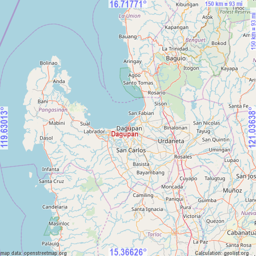
Dagupan GPS coordinates[2]
16° 2' 35.268" North, 120° 19' 59.7" East
| Map corner | latitude | longitude |
|---|---|---|
| Upper-left | 16.71771°, | 119.63013° |
| Center: | 16.04313°, | 120.33325° |
| Lower-right: | 15.36626°, | 121.03638° |
| Map W x H: | 150.3×150.3 km | = 93.4×93.4mi |
| max Lat: | 20.78733° ⇑11.9% North |
| Dagupan: | 16.04313° |
| min Lat: | ⇓88.1% South 4.65442° |
| min Long | Dagupan | max Long |
| 117.04868° | 120.33325° | 126.58417° |
| W 5.1%⇐ | ⇒94.9% E |
Elevation
Elevation of Dagupan is 8 m = 26 ft, and this is 79.9 m = 262 ft below average elevation for this country.
| Max E: |
2262 m = 7421 ft | 85.4% |
| Avg. | 87.9 m = 288 ft | |
| Dagupan | 8 m = 26 ft | |
Min E: |
-2 m = -7 ft | 14.6% |
See also: Dagupan elevation on elevation.city.
Geographical zone
Dagupan is located in North Torrid zone (between Equator and Tropic of Cancer). Distance of this Northern Tropic circle is 822.1 km =510.8 mi to North.| Distance of | km | miles | from Dagupan |
|---|---|---|---|
| North Pole | 8223.2 | 5109.7 | to North |
| Arctic Circle | 5617.3 | 3490.4 | to North |
| Tropic Cancer | 822.1 | 510.8 | to North |
| Equator | 1783.8 | 1108.4 | to South |


Nearby cities:
15 places around Dagupan: (largest is in red/bold)
• Balogo
8 km =5 mi,  222°
222°
• Binmaley
7 km =4.3 mi,  260°
260°
• Calasiao
4.6 km =2.9 mi,  141°
141°
• Camaley
6.2 km =3.9 mi,  213°
213°
• Canaoalan
4.2 km =2.6 mi,  248°
248°
• Doyong
8.2 km =5.1 mi,  164°
164°
• Gayaman
4.2 km =2.6 mi, 220°
• Malabago
7.4 km =4.6 mi, 158°
• Malanay
9 km =5.6 mi,  115°
115°
• Mangaldan
8 km =5 mi,  68°
68°
• Nagsaing
7 km =4.3 mi,  175°
175°
• Naguelguel
8.5 km =5.3 mi,  240°
240°
• Naguilayan
6.3 km =3.9 mi,  225°
225°
• Santa Barbara
8.7 km =5.4 mi, 122°
• Sonquil
8.7 km =5.4 mi,  134°
134°
Sources, notices
• [Note1] Compared only with cities in Philippines existing in our database
• [Src1] Map data: © OpenStreetMap contributors (CC-BY-SA)
• [Src2] Other city data from geonames.org with taken over terms of usage.
• [Src3] Geographical zone / Annual Mean Temperature by Robert A. Rohde @ Wikipedia
