Malicboy geodata
Malicboy (Calabarzon) is a populated place; located in Philippines in Asia/Manila (GMT+8) time zone. With population of 6,224 people, there are 1001 cities with bigger population in this country. Compared to other cities in Philippines, 68.7% of cities are located further ↓South; 62.7% of cities are located further →East and 70.2% of cities have higher elevation than Malicboy. Note1


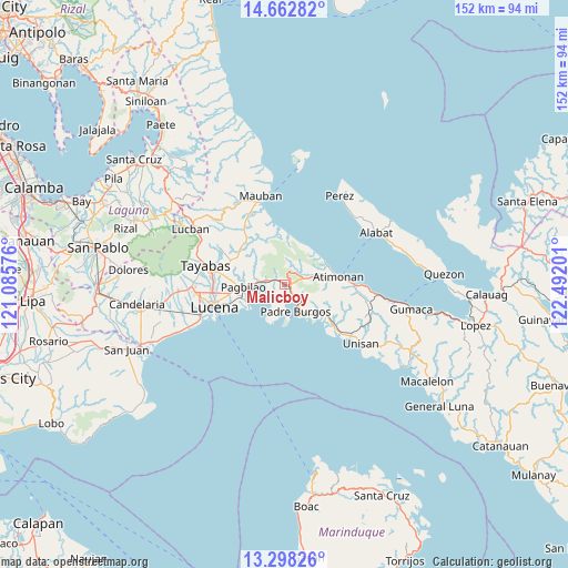
Malicboy GPS coordinates[2]
13° 58' 53.58" North, 121° 47' 19.968" East
| Map corner | latitude | longitude |
|---|---|---|
| Upper-left | 14.66282°, | 121.08576° |
| Center: | 13.98155°, | 121.78888° |
| Lower-right: | 13.29826°, | 122.49201° |
| Map W x H: | 151.7×151.7 km | = 94.3×94.3mi |
| max Lat: | 20.78733° ⇑31.3% North |
| Malicboy: | 13.98155° |
| min Lat: | ⇓68.7% South 4.65442° |
| min Long | Malicboy | max Long |
| 117.04868° | 121.78888° | 126.58417° |
| W 37.3%⇐ | ⇒62.7% E |
Elevation
Elevation of Malicboy is 12 m = 39 ft, and this is 75.9 m = 249 ft below average elevation for this country.
| Max E: |
2262 m = 7421 ft | 70.2% |
| Avg. | 87.9 m = 288 ft | |
| Malicboy | 12 m = 39 ft | |
Min E: |
-2 m = -7 ft | 29.8% |
See also: Philippines elevation on elevation.city.
Geographical zone
Malicboy is located in North Torrid zone (between Equator and Tropic of Cancer). Distance of this Northern Tropic circle is 1051.3 km =653.2 mi to North.| Distance of | km | miles | from Malicboy |
|---|---|---|---|
| North Pole | 8452.5 | 5252.1 | to North |
| Arctic Circle | 5846.6 | 3632.9 | to North |
| Tropic Cancer | 1051.3 | 653.2 | to North |
| Equator | 1554.6 | 966 | to South |


Nearby cities:
15 places around Malicboy: (largest is in red/bold)
• Agdangan
17.7 km =11 mi,  130°
130°
• Atimonan
14.4 km =8.9 mi,  80°
80°
• Binahaan
3.9 km =2.4 mi,  286°
286°
• Calilayan
21.1 km =13.1 mi, 133°
• Isabang
23.7 km =14.7 mi,  263°
263°
• Lucena
19.3 km =12 mi,  253°
253°
• Malinao Ilaya
5.3 km =3.3 mi,  72°
72°
• Marao
8.4 km =5.2 mi,  153°
153°
• Mauban
24.1 km =15 mi,  344°
344°
• Padre Burgos
7 km =4.3 mi,  159°
159°
• Pagbilao
9.9 km =6.2 mi, 260°
• Plaridel
25.2 km =15.7 mi,  96°
96°
• Talipan
12.6 km =7.8 mi,  244°
244°
• Tayabas
21.7 km =13.5 mi,  283°
283°
• Unisan
25.4 km =15.8 mi, 127°
Sources, notices
• [Note1] Compared only with cities in Philippines existing in our database
• [Src1] Map data: © OpenStreetMap contributors (CC-BY-SA)
• [Src2] Other city data from geonames.org with taken over terms of usage.
• [Src3] Geographical zone / Annual Mean Temperature by Robert A. Rohde @ Wikipedia
