Mauban geodata
Mauban (Calabarzon) is a populated place; located in Philippines in Asia/Manila (GMT+8) time zone. With population of 32,739 people, there are 260 cities with bigger population in this country. Compared to other cities in Philippines, 71.8% of cities are located further ↓South; 63.6% of cities are located further →East and 89.7% of cities have higher elevation than Mauban. Note1


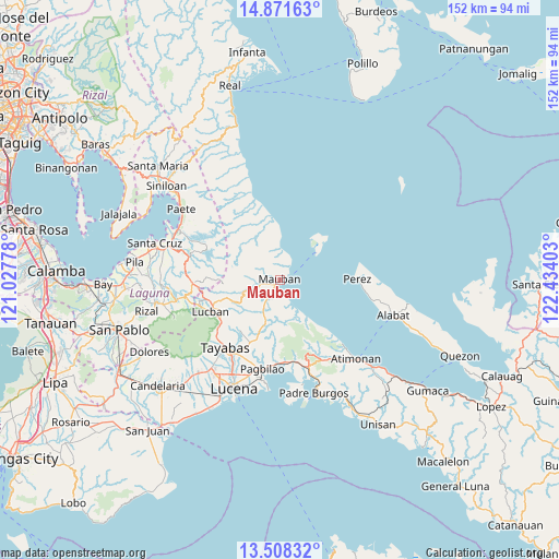
Mauban GPS coordinates[2]
14° 11' 27.6" North, 121° 43' 51.24" East
| Map corner | latitude | longitude |
|---|---|---|
| Upper-left | 14.87163°, | 121.02778° |
| Center: | 14.191°, | 121.7309° |
| Lower-right: | 13.50832°, | 122.43403° |
| Map W x H: | 151.6×151.6 km | = 94.2×94.2mi |
| max Lat: | 20.78733° ⇑28.2% North |
| Mauban: | 14.191° |
| min Lat: | ⇓71.8% South 4.65442° |
| min Long | Mauban | max Long |
| 117.04868° | 121.7309° | 126.58417° |
| W 36.4%⇐ | ⇒63.6% E |
Elevation
Elevation of Mauban is 7 m = 23 ft, and this is 80.9 m = 265 ft below average elevation for this country.
| Max E: |
2262 m = 7421 ft | 89.7% |
| Avg. | 87.9 m = 288 ft | |
| Mauban | 7 m = 23 ft | |
Min E: |
-2 m = -7 ft | 10.3% |
See also: Philippines elevation on elevation.city.
Geographical zone
Mauban is located in North Torrid zone (between Equator and Tropic of Cancer). Distance of this Northern Tropic circle is 1028 km =638.8 mi to North.| Distance of | km | miles | from Mauban |
|---|---|---|---|
| North Pole | 8429.2 | 5237.7 | to North |
| Arctic Circle | 5823.3 | 3618.4 | to North |
| Tropic Cancer | 1028 | 638.8 | to North |
| Equator | 1577.9 | 980.5 | to South |


Nearby cities:
15 places around Mauban: (largest is in red/bold)
• Binahaan
22.3 km =13.9 mi,  173°
173°
• Cagsiay
3.5 km =2.2 mi,  35°
35°
• Cavinti
24.8 km =15.4 mi,  283°
283°
• Kalayaan
25 km =15.5 mi,  314°
314°
• Lucban
20.8 km =12.9 mi,  245°
245°
• Luisiana
23.7 km =14.7 mi,  268°
268°
• Malicboy
24.1 km =15 mi,  164°
164°
• Malinao Ilaya
24.4 km =15.2 mi,  152°
152°
• Pagbilao
25.2 km =15.7 mi,  188°
188°
• Perez
21.1 km =13.1 mi,  88°
88°
• Sampaloc
10.3 km =6.4 mi, 252°
• San Antonio
24.9 km =15.5 mi, 272°
• San Diego
26.3 km =16.3 mi, 269°
• Santo Tomas
24.9 km =15.5 mi, 268°
• Tayabas
23.6 km =14.7 mi,  219°
219°
Sources, notices
• [Note1] Compared only with cities in Philippines existing in our database
• [Src1] Map data: © OpenStreetMap contributors (CC-BY-SA)
• [Src2] Other city data from geonames.org with taken over terms of usage.
• [Src3] Geographical zone / Annual Mean Temperature by Robert A. Rohde @ Wikipedia
