Atimonan geodata
Atimonan (Calabarzon) is a populated place; located in Philippines in Asia/Manila (GMT+8) time zone. With population of 29,356 people, there are 281 cities with bigger population in this country. Compared to other cities in Philippines, 69.2% of cities are located further ↓South; 61.3% of cities are located further →East and 85.4% of cities have higher elevation than Atimonan. Note1


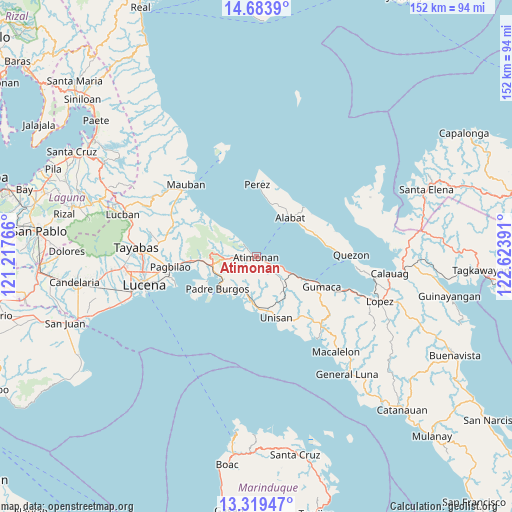
Atimonan GPS coordinates[2]
14° 0' 9.72" North, 121° 55' 14.808" East
| Map corner | latitude | longitude |
|---|---|---|
| Upper-left | 14.6839°, | 121.21766° |
| Center: | 14.0027°, | 121.92078° |
| Lower-right: | 13.31947°, | 122.62391° |
| Map W x H: | 151.7×151.7 km | = 94.3×94.3mi |
| max Lat: | 20.78733° ⇑30.8% North |
| Atimonan: | 14.0027° |
| min Lat: | ⇓69.2% South 4.65442° |
| min Long | Atimonan | max Long |
| 117.04868° | 121.92078° | 126.58417° |
| W 38.7%⇐ | ⇒61.3% E |
Elevation
Elevation of Atimonan is 8 m = 26 ft, and this is 79.9 m = 262 ft below average elevation for this country.
| Max E: |
2262 m = 7421 ft | 85.4% |
| Avg. | 87.9 m = 288 ft | |
| Atimonan | 8 m = 26 ft | |
Min E: |
-2 m = -7 ft | 14.6% |
See also: Philippines elevation on elevation.city.
Geographical zone
Atimonan is located in North Torrid zone (between Equator and Tropic of Cancer). Distance of this Northern Tropic circle is 1049 km =651.8 mi to North.| Distance of | km | miles | from Atimonan |
|---|---|---|---|
| North Pole | 8450.1 | 5250.6 | to North |
| Arctic Circle | 5844.2 | 3631.4 | to North |
| Tropic Cancer | 1049 | 651.8 | to North |
| Equator | 1557 | 967.5 | to South |


Nearby cities:
15 places around Atimonan: (largest is in red/bold)
• Agdangan
14 km =8.7 mi,  183°
183°
• Alabat
14.7 km =9.1 mi,  42°
42°
• Binahaan
18 km =11.2 mi,  266°
266°
• Calilayan
17 km =10.6 mi, 176°
• Gumaca
21.4 km =13.3 mi,  115°
115°
• Mabunga
22.2 km =13.8 mi,  134°
134°
• Mainit Norte
19.4 km =12.1 mi,  20°
20°
• Malicboy
14.4 km =8.9 mi,  260°
260°
• Malinao Ilaya
9.2 km =5.7 mi, 265°
• Marao
14.3 km =8.9 mi,  226°
226°
• Padre Burgos
14.8 km =9.2 mi, 232°
• Perez
21.4 km =13.3 mi,  1°
1°
• Plaridel
12 km =7.5 mi, 116°
• Progreso
21.1 km =13.1 mi, 119°
• Unisan
18.9 km =11.7 mi,  161°
161°
Sources, notices
• [Note1] Compared only with cities in Philippines existing in our database
• [Src1] Map data: © OpenStreetMap contributors (CC-BY-SA)
• [Src2] Other city data from geonames.org with taken over terms of usage.
• [Src3] Geographical zone / Annual Mean Temperature by Robert A. Rohde @ Wikipedia
