Lomboy geodata
Lomboy (Central Luzon) is a populated place; located in Philippines in Asia/Manila (GMT+8) time zone. With population of 3,282 people, there are 2230 cities with bigger population in this country. Compared to other cities in Philippines, 81.6% of cities are located further ↓South; 84.5% of cities are located further →East and 52.3% of cities have lower elevation than Lomboy. Note1


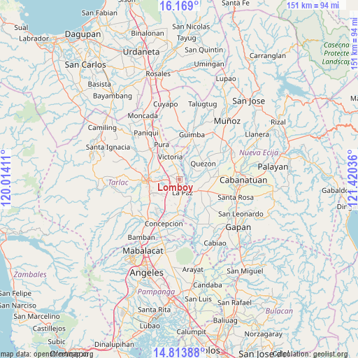
Lomboy GPS coordinates[2]
15° 29' 33.18" North, 120° 43' 2.028" East
| Map corner | latitude | longitude |
|---|---|---|
| Upper-left | 16.169°, | 120.01411° |
| Center: | 15.49255°, | 120.71723° |
| Lower-right: | 14.81388°, | 121.42036° |
| Map W x H: | 150.7×150.7 km | = 93.6×93.6mi |
| max Lat: | 20.78733° ⇑18.4% North |
| Lomboy: | 15.49255° |
| min Lat: | ⇓81.6% South 4.65442° |
| min Long | Lomboy | max Long |
| 117.04868° | 120.71723° | 126.58417° |
| W 15.5%⇐ | ⇒84.5% E |
Elevation
Elevation of Lomboy is 25 m = 82 ft, and this is 62.9 m = 206 ft below average elevation for this country.
| Max E: |
2262 m = 7421 ft | 47.7% |
| Avg. | 87.9 m = 288 ft | |
| Lomboy | 25 m = 82 ft | |
Min E: |
-2 m = -7 ft | 52.3% |
See also: Philippines elevation on elevation.city.
Geographical zone
Lomboy is located in North Torrid zone (between Equator and Tropic of Cancer). Distance of this Northern Tropic circle is 883.3 km =548.9 mi to North.| Distance of | km | miles | from Lomboy |
|---|---|---|---|
| North Pole | 8284.5 | 5147.7 | to North |
| Arctic Circle | 5678.6 | 3528.5 | to North |
| Tropic Cancer | 883.3 | 548.9 | to North |
| Equator | 1722.6 | 1070.4 | to South |


Nearby cities:
15 places around Lomboy: (largest is in red/bold)
• Amucao
4.6 km =2.9 mi,  226°
226°
• Balayang
6.8 km =4.2 mi,  338°
338°
• Balingcanaway
3.6 km =2.2 mi,  251°
251°
• Bundoc
0.8 km =0.5 mi,  178°
178°
• Dumarais
7 km =4.3 mi,  202°
202°
• La Paz
5.8 km =3.6 mi,  167°
167°
• Licab
7.6 km =4.7 mi,  40°
40°
• Matayumtayum
2.8 km =1.7 mi, 343°
• San Cristobal
8.7 km =5.4 mi, 38°
• San Isidro
5.6 km =3.5 mi, 170°
• San Jacinto
7.7 km =4.8 mi,  318°
318°
• San Manuel
5.6 km =3.5 mi,  267°
267°
• San Pascual
5.5 km =3.4 mi,  280°
280°
• Santa Lucia
6.3 km =3.9 mi,  100°
100°
• Villarosa
7.3 km =4.5 mi,  28°
28°
Sources, notices
• [Note1] Compared only with cities in Philippines existing in our database
• [Src1] Map data: © OpenStreetMap contributors (CC-BY-SA)
• [Src2] Other city data from geonames.org with taken over terms of usage.
• [Src3] Geographical zone / Annual Mean Temperature by Robert A. Rohde @ Wikipedia
