Lambakin geodata
Lambakin (Central Luzon) is a populated place; located in Philippines in Asia/Manila (GMT+8) time zone. With population of 2,995 people, there are 2532 cities with bigger population in this country. Compared to other cities in Philippines, 80.5% of cities are located further ↓South; 80.7% of cities are located further →East and 51.1% of cities have lower elevation than Lambakin. Note1


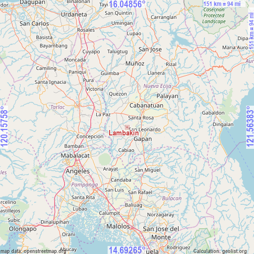
Lambakin GPS coordinates[2]
15° 22' 18.156" North, 120° 51' 38.52" East
| Map corner | latitude | longitude |
|---|---|---|
| Upper-left | 16.04856°, | 120.15758° |
| Center: | 15.37171°, | 120.8607° |
| Lower-right: | 14.69265°, | 121.56383° |
| Map W x H: | 150.8×150.8 km | = 93.7×93.7mi |
| max Lat: | 20.78733° ⇑19.5% North |
| Lambakin: | 15.37171° |
| min Lat: | ⇓80.5% South 4.65442° |
| min Long | Lambakin | max Long |
| 117.04868° | 120.8607° | 126.58417° |
| W 19.3%⇐ | ⇒80.7% E |
Elevation
Elevation of Lambakin is 24 m = 79 ft, and this is 63.9 m = 210 ft below average elevation for this country.
| Max E: |
2262 m = 7421 ft | 48.9% |
| Avg. | 87.9 m = 288 ft | |
| Lambakin | 24 m = 79 ft | |
Min E: |
-2 m = -7 ft | 51.1% |
See also: Philippines elevation on elevation.city.
Geographical zone
Lambakin is located in North Torrid zone (between Equator and Tropic of Cancer). Distance of this Northern Tropic circle is 896.7 km =557.2 mi to North.| Distance of | km | miles | from Lambakin |
|---|---|---|---|
| North Pole | 8297.9 | 5156.1 | to North |
| Arctic Circle | 5692 | 3536.8 | to North |
| Tropic Cancer | 896.7 | 557.2 | to North |
| Equator | 1709.2 | 1062 | to South |


Nearby cities:
15 places around Lambakin: (largest is in red/bold)
• Alua
7.6 km =4.7 mi,  151°
151°
• Batitang
7 km =4.3 mi,  297°
297°
• Jaen
8 km =5 mi,  128°
128°
• Lawang Kupang
2.7 km =1.7 mi,  187°
187°
• Marawa
5.6 km =3.5 mi,  334°
334°
• Papaya
6.3 km =3.9 mi,  205°
205°
• Putlod
0.7 km =0.4 mi,  99°
99°
• San Anton
6.9 km =4.3 mi,  112°
112°
• San Antonio
7.3 km =4.5 mi,  183°
183°
• San Francisco
2.8 km =1.7 mi,  231°
231°
• San Mariano
5.9 km =3.7 mi,  163°
163°
• Santa Barbara
7.1 km =4.4 mi,  281°
281°
• Santa Cruz
7.1 km =4.4 mi, 186°
• Santo Rosario
7.6 km =4.7 mi,  24°
24°
• Tikiw
6.6 km =4.1 mi, 179°
Sources, notices
• [Note1] Compared only with cities in Philippines existing in our database
• [Src1] Map data: © OpenStreetMap contributors (CC-BY-SA)
• [Src2] Other city data from geonames.org with taken over terms of usage.
• [Src3] Geographical zone / Annual Mean Temperature by Robert A. Rohde @ Wikipedia
