Santo Rosario geodata
Santo Rosario (Central Luzon) is a populated place; located in Philippines in Asia/Manila (GMT+8) time zone. With population of 6,005 people, there are 1043 cities with bigger population in this country. Compared to other cities in Philippines, 81% of cities are located further ↓South; 79.7% of cities are located further →East and 54.4% of cities have lower elevation than Santo Rosario. Note1
Administrative division(s):
- Level 1: Central Luzon
- Level 2: Province of Nueva Ecija
- Level 3: Santa Rosa


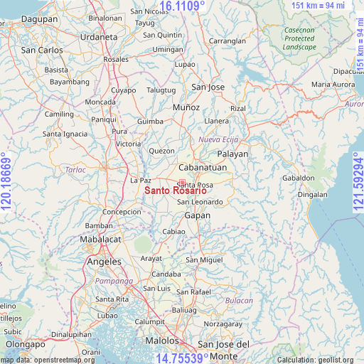
Santo Rosario GPS coordinates[2]
15° 26' 3.3" North, 120° 53' 23.316" East
| Map corner | latitude | longitude |
|---|---|---|
| Upper-left | 16.1109°, | 120.18669° |
| Center: | 15.43425°, | 120.88981° |
| Lower-right: | 14.75539°, | 121.59294° |
| Map W x H: | 150.7×150.7 km | = 93.6×93.6mi |
| max Lat: | 20.78733° ⇑19% North |
| Santo Rosario: | 15.43425° |
| min Lat: | ⇓81% South 4.65442° |
| min Long | Santo Rosario | max Long |
| 117.04868° | 120.88981° | 126.58417° |
| W 20.3%⇐ | ⇒79.7% E |
Elevation
Elevation of Santo Rosario is 27 m = 89 ft, and this is 60.9 m = 200 ft below average elevation for this country.
| Max E: |
2262 m = 7421 ft | 45.6% |
| Avg. | 87.9 m = 288 ft | |
| Santo Rosario | 27 m = 89 ft | |
Min E: |
-2 m = -7 ft | 54.4% |
See also: Philippines elevation on elevation.city.
Geographical zone
Santo Rosario is located in North Torrid zone (between Equator and Tropic of Cancer). Distance of this Northern Tropic circle is 889.8 km =552.9 mi to North.| Distance of | km | miles | from Santo Rosario |
|---|---|---|---|
| North Pole | 8290.9 | 5151.7 | to North |
| Arctic Circle | 5685 | 3532.5 | to North |
| Tropic Cancer | 889.8 | 552.9 | to North |
| Equator | 1716.1 | 1066.3 | to South |


Nearby cities:
15 places around Santo Rosario: (largest is in red/bold)
• Aliaga
8.9 km =5.5 mi,  325°
325°
• Batitang
10.1 km =6.3 mi,  248°
248°
• Cabanatuan City
10 km =6.2 mi,  55°
55°
• Carmen
6.9 km =4.3 mi,  281°
281°
• Concepcion
9.6 km =6 mi, 276°
• Lambakin
7.6 km =4.7 mi,  204°
204°
• Lawang Kupang
10.2 km =6.3 mi, 199°
• Marawa
5.8 km =3.6 mi, 251°
• Putlod
7.5 km =4.7 mi, 198°
• Rajal Norte
3.1 km =1.9 mi,  291°
291°
• San Anton
10.1 km =6.3 mi,  161°
161°
• San Felipe Old
7.7 km =4.8 mi,  14°
14°
• Santa Rosa
5.3 km =3.3 mi,  102°
102°
• Soledad
10.1 km =6.3 mi,  93°
93°
• Tabuating
7.2 km =4.5 mi,  130°
130°
Sources, notices
• [Note1] Compared only with cities in Philippines existing in our database
• [Src1] Map data: © OpenStreetMap contributors (CC-BY-SA)
• [Src2] Other city data from geonames.org with taken over terms of usage.
• [Src3] Geographical zone / Annual Mean Temperature by Robert A. Rohde @ Wikipedia
