Cumadcad geodata
Cumadcad (Bicol) is a populated place; located in Philippines in Asia/Manila (GMT+8) time zone. With population of 5,203 people, there are 1228 cities with bigger population in this country. Compared to other cities in Philippines, 57.2% of cities are located further ↓South; 67.8% of cities are located further ←West and 76% of cities have lower elevation than Cumadcad. Note1


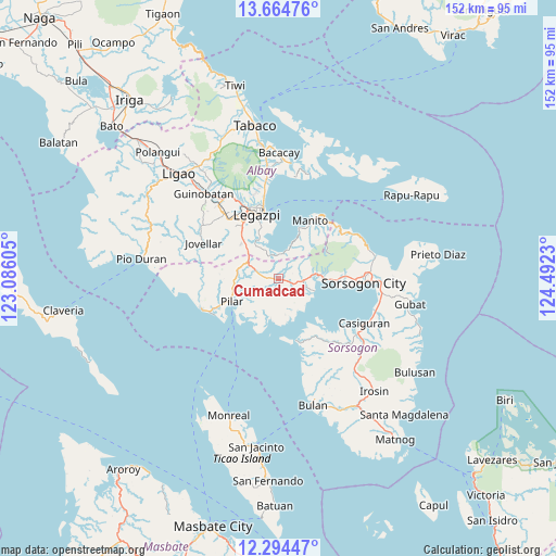
Cumadcad GPS coordinates[2]
12° 58' 50.016" North, 123° 47' 21.012" East
| Map corner | latitude | longitude |
|---|---|---|
| Upper-left | 13.66476°, | 123.08605° |
| Center: | 12.98056°, | 123.78917° |
| Lower-right: | 12.29447°, | 124.4923° |
| Map W x H: | 152.4×152.4 km | = 94.7×94.7mi |
| max Lat: | 20.78733° ⇑42.8% North |
| Cumadcad: | 12.98056° |
| min Lat: | ⇓57.2% South 4.65442° |
| min Long | Cumadcad | max Long |
| 117.04868° | 123.78917° | 126.58417° |
| W 67.8%⇐ | ⇒32.2% E |
Elevation
Elevation of Cumadcad is 72 m = 236 ft, and this is 15.9 m = 52 ft below average elevation for this country.
| Max E: |
2262 m = 7421 ft | 24% |
| Avg. | 87.9 m = 288 ft | |
| Cumadcad | 72 m = 236 ft | |
Min E: |
-2 m = -7 ft | 76% |
See also: Philippines elevation on elevation.city.
Geographical zone
Cumadcad is located in North Torrid zone (between Equator and Tropic of Cancer). Distance of this Northern Tropic circle is 1162.6 km =722.4 mi to North.| Distance of | km | miles | from Cumadcad |
|---|---|---|---|
| North Pole | 8563.8 | 5321.3 | to North |
| Arctic Circle | 5957.9 | 3702.1 | to North |
| Tropic Cancer | 1162.6 | 722.4 | to North |
| Equator | 1443.3 | 896.8 | to South |


Nearby cities:
15 places around Cumadcad: (largest is in red/bold)
• Aanislag
14 km =8.7 mi,  318°
318°
• Abucay
15.2 km =9.4 mi,  270°
270°
• Bangkirohan
9.5 km =5.9 mi,  331°
331°
• Cabiguan
10.4 km =6.5 mi,  216°
216°
• Castilla
10.7 km =6.6 mi,  109°
109°
• Macalaya
10.3 km =6.4 mi,  190°
190°
• Maslog
13.9 km =8.6 mi,  352°
352°
• Pilar
14.2 km =8.8 mi,  243°
243°
• Pili
8.1 km =5 mi,  90°
90°
• Putiao
9.1 km =5.7 mi,  298°
298°
• Rizal
13.5 km =8.4 mi, 91°
• San Francisco
6.3 km =3.9 mi, 354°
• San Isidro
7.4 km =4.6 mi,  95°
95°
• San Vicente
3.6 km =2.2 mi, 94°
• Villahermosa
11 km =6.8 mi,  311°
311°
Sources, notices
• [Note1] Compared only with cities in Philippines existing in our database
• [Src1] Map data: © OpenStreetMap contributors (CC-BY-SA)
• [Src2] Other city data from geonames.org with taken over terms of usage.
• [Src3] Geographical zone / Annual Mean Temperature by Robert A. Rohde @ Wikipedia
