Abucay geodata
Abucay (Bicol) is a populated place; located in Philippines in Asia/Manila (GMT+8) time zone. With population of 2,863 people, there are 2688 cities with bigger population in this country. Compared to other cities in Philippines, 57.2% of cities are located further ↓South; 64.7% of cities are located further ←West and 51.8% of cities have higher elevation than Abucay. Note1


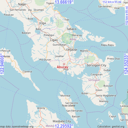
Abucay GPS coordinates[2]
12° 58' 55.2" North, 123° 38' 57.12" East
| Map corner | latitude | longitude |
|---|---|---|
| Upper-left | 13.66619°, | 122.94608° |
| Center: | 12.982°, | 123.6492° |
| Lower-right: | 12.29592°, | 124.35233° |
| Map W x H: | 152.4×152.4 km | = 94.7×94.7mi |
| max Lat: | 20.78733° ⇑42.8% North |
| Abucay: | 12.982° |
| min Lat: | ⇓57.2% South 4.65442° |
| min Long | Abucay | max Long |
| 117.04868° | 123.6492° | 126.58417° |
| W 64.7%⇐ | ⇒35.3% E |
Elevation
Elevation of Abucay is 22 m = 72 ft, and this is 65.9 m = 216 ft below average elevation for this country.
| Max E: |
2262 m = 7421 ft | 51.8% |
| Avg. | 87.9 m = 288 ft | |
| Abucay | 22 m = 72 ft | |
Min E: |
-2 m = -7 ft | 48.2% |
See also: Philippines elevation on elevation.city.
Geographical zone
Abucay is located in North Torrid zone (between Equator and Tropic of Cancer). Distance of this Northern Tropic circle is 1162.5 km =722.3 mi to North.| Distance of | km | miles | from Abucay |
|---|---|---|---|
| North Pole | 8563.6 | 5321.2 | to North |
| Arctic Circle | 5957.7 | 3701.9 | to North |
| Tropic Cancer | 1162.5 | 722.3 | to North |
| Equator | 1443.5 | 896.9 | to South |


Nearby cities:
15 places around Abucay: (largest is in red/bold)
• Aanislag
11.9 km =7.4 mi,  29°
29°
• Bangkirohan
13.3 km =8.3 mi,  52°
52°
• Barayong
15 km =9.3 mi, 29°
• Bascaron
14.5 km =9 mi,  22°
22°
• Cabiguan
12.3 km =7.6 mi,  133°
133°
• Cotmon
15.1 km =9.4 mi,  5°
5°
• Dangcalan
10.1 km =6.3 mi,  224°
224°
• Donsol
10.3 km =6.4 mi,  214°
214°
• Jovellar
11.1 km =6.9 mi,  331°
331°
• Ogod
9.7 km =6 mi,  201°
201°
• Pilar
7 km =4.3 mi,  158°
158°
• Putiao
8.2 km =5.1 mi,  59°
59°
• Salvacion
10.1 km =6.3 mi,  339°
339°
• San Rafael
10.8 km =6.7 mi, 160°
• Villahermosa
9.9 km =6.2 mi,  44°
44°
Sources, notices
• [Note1] Compared only with cities in Philippines existing in our database
• [Src1] Map data: © OpenStreetMap contributors (CC-BY-SA)
• [Src2] Other city data from geonames.org with taken over terms of usage.
• [Src3] Geographical zone / Annual Mean Temperature by Robert A. Rohde @ Wikipedia
