Macalaya geodata
Macalaya (Bicol) is a populated place; located in Philippines in Asia/Manila (GMT+8) time zone. With population of 3,673 people, there are 1931 cities with bigger population in this country. Compared to other cities in Philippines, 56.7% of cities are located further ↓South; 67.4% of cities are located further ←West and 53.1% of cities have higher elevation than Macalaya. Note1


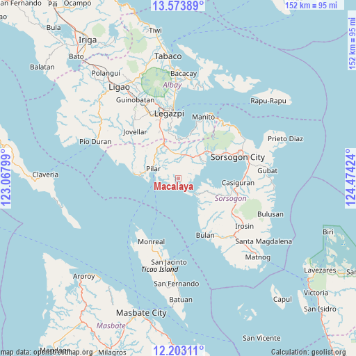
Macalaya GPS coordinates[2]
12° 53' 21.984" North, 123° 46' 15.996" East
| Map corner | latitude | longitude |
|---|---|---|
| Upper-left | 13.57389°, | 123.06799° |
| Center: | 12.88944°, | 123.77111° |
| Lower-right: | 12.20311°, | 124.47424° |
| Map W x H: | 152.4×152.4 km | = 94.7×94.7mi |
| max Lat: | 20.78733° ⇑43.3% North |
| Macalaya: | 12.88944° |
| min Lat: | ⇓56.7% South 4.65442° |
| min Long | Macalaya | max Long |
| 117.04868° | 123.77111° | 126.58417° |
| W 67.4%⇐ | ⇒32.6% E |
Elevation
Elevation of Macalaya is 21 m = 69 ft, and this is 66.9 m = 219 ft below average elevation for this country.
| Max E: |
2262 m = 7421 ft | 53.1% |
| Avg. | 87.9 m = 288 ft | |
| Macalaya | 21 m = 69 ft | |
Min E: |
-2 m = -7 ft | 46.9% |
See also: Philippines elevation on elevation.city.
Geographical zone
Macalaya is located in North Torrid zone (between Equator and Tropic of Cancer). Distance of this Northern Tropic circle is 1172.7 km =728.7 mi to North.| Distance of | km | miles | from Macalaya |
|---|---|---|---|
| North Pole | 8573.9 | 5327.6 | to North |
| Arctic Circle | 5968 | 3708.3 | to North |
| Tropic Cancer | 1172.7 | 728.7 | to North |
| Equator | 1433.2 | 890.5 | to South |


Nearby cities:
15 places around Macalaya: (largest is in red/bold)
• Abucay
16.7 km =10.4 mi,  307°
307°
• Aguada
10.5 km =6.5 mi,  140°
140°
• Cabiguan
4.7 km =2.9 mi,  292°
292°
• Caditaan
12.6 km =7.8 mi, 137°
• Castilla
13.7 km =8.5 mi,  61°
61°
• Cumadcad
10.3 km =6.4 mi,  10°
10°
• Magallanes
9.7 km =6 mi,  133°
133°
• Ogod
16.8 km =10.4 mi,  274°
274°
• Pilar
11.3 km =7 mi, 289°
• Pili
14.3 km =8.9 mi,  44°
44°
• Putiao
15.7 km =9.8 mi,  337°
337°
• San Francisco
16.4 km =10.2 mi,  4°
4°
• San Isidro
13.3 km =8.3 mi, 44°
• San Rafael
9.6 km =6 mi, 270°
• San Vicente
11.3 km =7 mi,  29°
29°
Sources, notices
• [Note1] Compared only with cities in Philippines existing in our database
• [Src1] Map data: © OpenStreetMap contributors (CC-BY-SA)
• [Src2] Other city data from geonames.org with taken over terms of usage.
• [Src3] Geographical zone / Annual Mean Temperature by Robert A. Rohde @ Wikipedia
