Kanluran geodata
Kanluran (Calabarzon) is a populated place; located in Philippines in Asia/Manila (GMT+8) time zone. With population of 2,312 people, there are 3648 cities with bigger population in this country. Compared to other cities in Philippines, 73.6% of cities are located further ↓South; 81% of cities are located further →East and 89.7% of cities have higher elevation than Kanluran. Note1


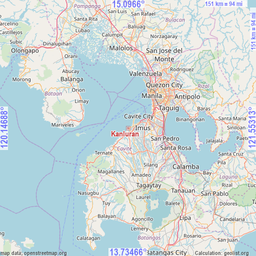
Kanluran GPS coordinates[2]
14° 25' 0.012" North, 120° 51' 0" East
| Map corner | latitude | longitude |
|---|---|---|
| Upper-left | 15.0966°, | 120.14688° |
| Center: | 14.41667°, | 120.85° |
| Lower-right: | 13.73466°, | 121.55313° |
| Map W x H: | 151.4×151.4 km | = 94.1×94.1mi |
| max Lat: | 20.78733° ⇑26.4% North |
| Kanluran: | 14.41667° |
| min Lat: | ⇓73.6% South 4.65442° |
| min Long | Kanluran | max Long |
| 117.04868° | 120.85° | 126.58417° |
| W 19%⇐ | ⇒81% E |
Elevation
Elevation of Kanluran is 7 m = 23 ft, and this is 80.9 m = 265 ft below average elevation for this country.
| Max E: |
2262 m = 7421 ft | 89.7% |
| Avg. | 87.9 m = 288 ft | |
| Kanluran | 7 m = 23 ft | |
Min E: |
-2 m = -7 ft | 10.3% |
See also: Philippines elevation on elevation.city.
Geographical zone
Kanluran is located in North Torrid zone (between Equator and Tropic of Cancer). Distance of this Northern Tropic circle is 1002.9 km =623.2 mi to North.| Distance of | km | miles | from Kanluran |
|---|---|---|---|
| North Pole | 8404.1 | 5222.1 | to North |
| Arctic Circle | 5798.2 | 3602.8 | to North |
| Tropic Cancer | 1002.9 | 623.2 | to North |
| Equator | 1603 | 996.1 | to South |


Nearby cities:
15 places around Kanluran: (largest is in red/bold)
• Bacoor
10.6 km =6.6 mi,  63°
63°
• Cavite City
9.1 km =5.7 mi,  35°
35°
• Dasmariñas
13.5 km =8.4 mi,  136°
136°
• General Trias
4.7 km =2.9 mi,  134°
134°
• Halayhay
6.2 km =3.9 mi,  219°
219°
• Imus
9.4 km =5.8 mi,  81°
81°
• Kawit
6.4 km =4 mi, 61°
• Naic
14.2 km =8.8 mi, 219°
• Noveleta
3.5 km =2.2 mi,  66°
66°
• Paradahan
10.7 km =6.6 mi,  173°
173°
• Pasong Kawayan Primero
8.9 km =5.5 mi,  157°
157°
• Rosario
0.8 km =0.5 mi, 77°
• Sabang
13.3 km =8.3 mi,  202°
202°
• Santa Rosa
3.3 km =2.1 mi, 71°
• Tanza
2.1 km =1.3 mi, 163°
Sources, notices
• [Note1] Compared only with cities in Philippines existing in our database
• [Src1] Map data: © OpenStreetMap contributors (CC-BY-SA)
• [Src2] Other city data from geonames.org with taken over terms of usage.
• [Src3] Geographical zone / Annual Mean Temperature by Robert A. Rohde @ Wikipedia
