Paradahan geodata
Paradahan (Calabarzon) is a populated place; located in Philippines in Asia/Manila (GMT+8) time zone. With population of 8,977 people, there are 691 cities with bigger population in this country. Compared to other cities in Philippines, 73.1% of cities are located further ↓South; 80.7% of cities are located further →East and 74.3% of cities have lower elevation than Paradahan. Note1


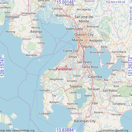
Paradahan GPS coordinates[2]
14° 19' 16.428" North, 120° 51' 38.124" East
| Map corner | latitude | longitude |
|---|---|---|
| Upper-left | 15.00146°, | 120.15747° |
| Center: | 14.32123°, | 120.86059° |
| Lower-right: | 13.63894°, | 121.56372° |
| Map W x H: | 151.5×151.5 km | = 94.1×94.1mi |
| max Lat: | 20.78733° ⇑26.9% North |
| Paradahan: | 14.32123° |
| min Lat: | ⇓73.1% South 4.65442° |
| min Long | Paradahan | max Long |
| 117.04868° | 120.86059° | 126.58417° |
| W 19.3%⇐ | ⇒80.7% E |
Elevation
Elevation of Paradahan is 66 m = 217 ft, and this is 21.9 m = 72 ft below average elevation for this country.
| Max E: |
2262 m = 7421 ft | 25.7% |
| Avg. | 87.9 m = 288 ft | |
| Paradahan | 66 m = 217 ft | |
Min E: |
-2 m = -7 ft | 74.3% |
See also: Philippines elevation on elevation.city.
Geographical zone
Paradahan is located in North Torrid zone (between Equator and Tropic of Cancer). Distance of this Northern Tropic circle is 1013.5 km =629.8 mi to North.| Distance of | km | miles | from Paradahan |
|---|---|---|---|
| North Pole | 8414.7 | 5228.7 | to North |
| Arctic Circle | 5808.8 | 3609.4 | to North |
| Tropic Cancer | 1013.5 | 629.8 | to North |
| Equator | 1592.4 | 989.5 | to South |


Nearby cities:
15 places around Paradahan: (largest is in red/bold)
• Aliang
4.9 km =3 mi,  149°
149°
• Bitangan
7.7 km =4.8 mi,  165°
165°
• Dasmariñas
8.2 km =5.1 mi,  83°
83°
• General Trias
7.7 km =4.8 mi,  17°
17°
• Halayhay
7.8 km =4.8 mi,  318°
318°
• Javalera
9.2 km =5.7 mi,  139°
139°
• Kanluran
10.7 km =6.6 mi,  353°
353°
• Malainen Luma
9.6 km =6 mi,  233°
233°
• Manggahan
5.5 km =3.4 mi,  126°
126°
• Naic
10.2 km =6.3 mi,  268°
268°
• Palangue
6.7 km =4.2 mi, 232°
• Pasong Kawayan Primero
3.3 km =2.1 mi,  42°
42°
• Rosario
10.8 km =6.7 mi,  358°
358°
• Sabang
6.4 km =4 mi,  254°
254°
• Tanza
8.6 km =5.3 mi, 356°
Sources, notices
• [Note1] Compared only with cities in Philippines existing in our database
• [Src1] Map data: © OpenStreetMap contributors (CC-BY-SA)
• [Src2] Other city data from geonames.org with taken over terms of usage.
• [Src3] Geographical zone / Annual Mean Temperature by Robert A. Rohde @ Wikipedia
