General Trias geodata
General Trias (Calabarzon) is a seat of a third-order administrative division; located in Philippines in Asia/Manila (GMT+8) time zone. With population of 96,022 people, there are 95 cities with bigger population in this country. Compared to other cities in Philippines, 73.5% of cities are located further ↓South; 79.9% of cities are located further →East and 51.8% of cities have higher elevation than General Trias. Note1
Administrative division(s):
- Level 1: Calabarzon
- Level 2: Province of Cavite
- Level 3: City of General Trias


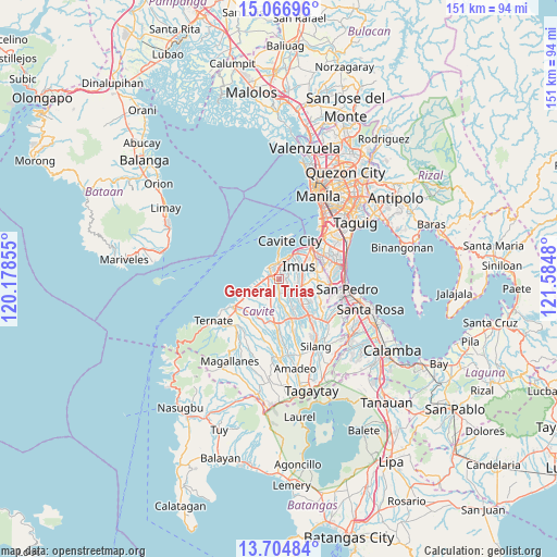
General Trias GPS coordinates[2]
14° 23' 12.984" North, 120° 52' 54.012" East
| Map corner | latitude | longitude |
|---|---|---|
| Upper-left | 15.06696°, | 120.17855° |
| Center: | 14.38694°, | 120.88167° |
| Lower-right: | 13.70484°, | 121.5848° |
| Map W x H: | 151.5×151.5 km | = 94.1×94.1mi |
| max Lat: | 20.78733° ⇑26.5% North |
| General Trias: | 14.38694° |
| min Lat: | ⇓73.5% South 4.65442° |
| min Long | General Trias | max Long |
| 117.04868° | 120.88167° | 126.58417° |
| W 20.1%⇐ | ⇒79.9% E |
Elevation
Elevation of General Trias is 22 m = 72 ft, and this is 65.9 m = 216 ft below average elevation for this country.
| Max E: |
2262 m = 7421 ft | 51.8% |
| Avg. | 87.9 m = 288 ft | |
| General Trias | 22 m = 72 ft | |
Min E: |
-2 m = -7 ft | 48.2% |
See also: General Trias elevation on elevation.city.
Geographical zone
General Trias is located in North Torrid zone (between Equator and Tropic of Cancer). Distance of this Northern Tropic circle is 1006.2 km =625.2 mi to North.| Distance of | km | miles | from General Trias |
|---|---|---|---|
| North Pole | 8407.4 | 5224.1 | to North |
| Arctic Circle | 5801.5 | 3604.9 | to North |
| Tropic Cancer | 1006.2 | 625.2 | to North |
| Equator | 1599.7 | 994 | to South |


Nearby cities:
15 places around General Trias: (largest is in red/bold)
• Aliang
11.5 km =7.1 mi,  179°
179°
• Bacoor
10.1 km =6.3 mi,  37°
37°
• Cavite City
10.9 km =6.8 mi,  9°
9°
• Dasmariñas
8.7 km =5.4 mi,  137°
137°
• Halayhay
7.5 km =4.7 mi,  258°
258°
• Imus
7.6 km =4.7 mi,  51°
51°
• Kanluran
4.7 km =2.9 mi,  314°
314°
• Kawit
6.7 km =4.2 mi,  18°
18°
• Manggahan
10.8 km =6.7 mi,  168°
168°
• Noveleta
4.7 km =2.9 mi,  357°
357°
• Paradahan
7.7 km =4.8 mi,  197°
197°
• Pasong Kawayan Primero
4.9 km =3 mi, 180°
• Rosario
4.3 km =2.7 mi,  323°
323°
• Santa Rosa
4.4 km =2.7 mi, 356°
• Tanza
3.1 km =1.9 mi,  294°
294°
Sources, notices
• [Note1] Compared only with cities in Philippines existing in our database
• [Src1] Map data: © OpenStreetMap contributors (CC-BY-SA)
• [Src2] Other city data from geonames.org with taken over terms of usage.
• [Src3] Geographical zone / Annual Mean Temperature by Robert A. Rohde @ Wikipedia
