Sabang geodata
Sabang (Calabarzon) is a populated place; located in Philippines in Asia/Manila (GMT+8) time zone. With population of 3,470 people, there are 2079 cities with bigger population in this country. Compared to other cities in Philippines, 73% of cities are located further ↓South; 82.1% of cities are located further →East and 62.9% of cities have lower elevation than Sabang. Note1


Sabang GPS coordinates[2]
14° 18' 20.016" North, 120° 48' 12.996" East
| Map corner | latitude | longitude |
|---|---|---|
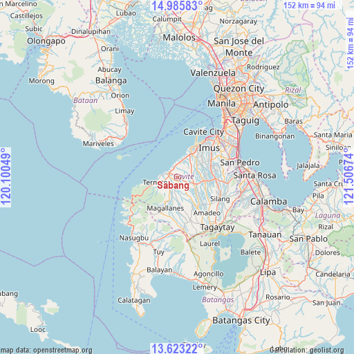
| Upper-left | 14.98583°, | 120.10049° |
| Center: | 14.30556°, | 120.80361° |
| Lower-right: | 13.62322°, | 121.50674° |
| Map W x H: | 151.5×151.5 km | = 94.1×94.1mi |
| max Lat: | 20.78733° ⇑27% North |
| Sabang: | 14.30556° |
| min Lat: | ⇓73% South 4.65442° |
| min Long | Sabang | max Long |
| 117.04868° | 120.80361° | 126.58417° |
| W 17.9%⇐ | ⇒82.1% E |
Elevation
Elevation of Sabang is 38 m = 125 ft, and this is 49.9 m = 164 ft below average elevation for this country.
| Max E: |
2262 m = 7421 ft | 37.1% |
| Avg. | 87.9 m = 288 ft | |
| Sabang | 38 m = 125 ft | |
Min E: |
-2 m = -7 ft | 62.9% |
See also: Philippines elevation on elevation.city.
Geographical zone
Sabang is located in North Torrid zone (between Equator and Tropic of Cancer). Distance of this Northern Tropic circle is 1015.3 km =630.9 mi to North.| Distance of | km | miles | from Sabang |
|---|---|---|---|
| North Pole | 8416.4 | 5229.7 | to North |
| Arctic Circle | 5810.5 | 3610.5 | to North |
| Tropic Cancer | 1015.3 | 630.9 | to North |
| Equator | 1590.6 | 988.4 | to South |


Nearby cities:
15 places around Sabang: (largest is in red/bold)
• Aliang
8.9 km =5.5 mi,  106°
106°
• Banaba
11.1 km =6.9 mi,  153°
153°
• Bitangan
9.9 km =6.2 mi,  125°
125°
• Halayhay
7.7 km =4.8 mi,  7°
7°
• Malainen Luma
4.2 km =2.6 mi,  202°
202°
• Manggahan
10.6 km =6.6 mi,  98°
98°
• Maragondon
8 km =5 mi,  243°
243°
• Naic
4.3 km =2.7 mi,  289°
289°
• Palangue
2.5 km =1.6 mi,  160°
160°
• Pantijan No 2
8.1 km =5 mi,  182°
182°
• Paradahan
6.4 km =4 mi,  74°
74°
• Pasong Kawayan Primero
9.4 km =5.8 mi,  63°
63°
• Tanza
11.7 km =7.3 mi,  28°
28°
• Ternate
9.5 km =5.9 mi,  259°
259°
• Tulay
5.4 km =3.4 mi,  222°
222°
Sources, notices
• [Note1] Compared only with cities in Philippines existing in our database
• [Src1] Map data: © OpenStreetMap contributors (CC-BY-SA)
• [Src2] Other city data from geonames.org with taken over terms of usage.
• [Src3] Geographical zone / Annual Mean Temperature by Robert A. Rohde @ Wikipedia
