Catmon geodata
Catmon (Central Visayas) is a seat of a third-order administrative division; located in Philippines in Asia/Manila (GMT+8) time zone. With population of 7,812 people, there are 790 cities with bigger population in this country. Compared to other cities in Philippines, 60.6% of cities are located further ↑North; 70.9% of cities are located further ←West and 78.9% of cities have lower elevation than Catmon. Note1


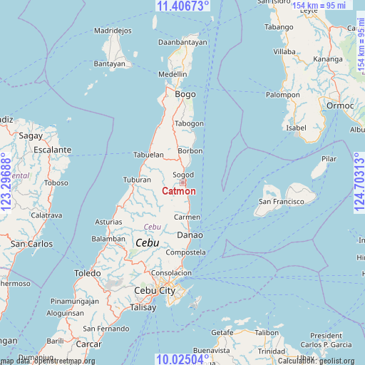
Catmon GPS coordinates[2]
10° 43' 0.012" North, 124° 0' 0" East
| Map corner | latitude | longitude |
|---|---|---|
| Upper-left | 11.40673°, | 123.29688° |
| Center: | 10.71667°, | 124° |
| Lower-right: | 10.02504°, | 124.70313° |
| Map W x H: | 153.6×153.6 km | = 95.4×95.4mi |
| max Lat: | 20.78733° ⇑60.6% North |
| Catmon: | 10.71667° |
| min Lat: | ⇓39.4% South 4.65442° |
| min Long | Catmon | max Long |
| 117.04868° | 124° | 126.58417° |
| W 70.9%⇐ | ⇒29.1% E |
Elevation
Elevation of Catmon is 85 m = 279 ft, and this is 2.9 m = 10 ft below average elevation for this country.
| Max E: |
2262 m = 7421 ft | 21.1% |
| Avg. | 87.9 m = 288 ft | |
| Catmon | 85 m = 279 ft | |
Min E: |
-2 m = -7 ft | 78.9% |
See also: Philippines elevation on elevation.city.
Geographical zone
Catmon is located in North Torrid zone (between Equator and Tropic of Cancer). Distance of Equator is 1191.6 km =740.4 mi to South.| Distance of | km | miles | from Catmon |
|---|---|---|---|
| North Pole | 8815.5 | 5477.7 | to North |
| Arctic Circle | 6209.6 | 3858.5 | to North |
| Tropic Cancer | 1414.3 | 878.8 | to North |
| Equator | 1191.6 | 740.4 | to South |


Nearby cities:
15 places around Catmon: (largest is in red/bold)
• Borbon
13.9 km =8.6 mi,  13°
13°
• Cabalawan
5.9 km =3.7 mi,  297°
297°
• Calumboyan
8.8 km =5.5 mi,  19°
19°
• Campusong
11.6 km =7.2 mi, 17°
• Catmondaan
3.7 km =2.3 mi,  153°
153°
• Cogan
13.9 km =8.6 mi,  171°
171°
• Damolog
6.3 km =3.9 mi, 6°
• Lugo
11.2 km =7 mi,  352°
352°
• Macaas
2.3 km =1.4 mi, 147°
• Panalipan
8 km =5 mi,  162°
162°
• Putat
18.4 km =11.4 mi,  294°
294°
• Sogod
3.8 km =2.4 mi, 351°
• Tabuelan
18.4 km =11.4 mi,  308°
308°
• Tabunok
6.9 km =4.3 mi, 14°
• Taytayan
18.2 km =11.3 mi, 352°
Sources, notices
• [Note1] Compared only with cities in Philippines existing in our database
• [Src1] Map data: © OpenStreetMap contributors (CC-BY-SA)
• [Src2] Other city data from geonames.org with taken over terms of usage.
• [Src3] Geographical zone / Annual Mean Temperature by Robert A. Rohde @ Wikipedia
