Cabalawan geodata
Cabalawan (Central Visayas) is a populated place; located in Philippines in Asia/Manila (GMT+8) time zone. With population of 2,859 people, there are 2696 cities with bigger population in this country. Compared to other cities in Philippines, 60.3% of cities are located further ↑North; 70.1% of cities are located further ←West and 92.5% of cities have lower elevation than Cabalawan. Note1


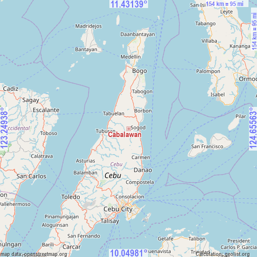
Cabalawan GPS coordinates[2]
10° 44' 29.004" North, 123° 57' 9" East
| Map corner | latitude | longitude |
|---|---|---|
| Upper-left | 11.43139°, | 123.24938° |
| Center: | 10.74139°, | 123.9525° |
| Lower-right: | 10.04981°, | 124.65563° |
| Map W x H: | 153.6×153.6 km | = 95.4×95.4mi |
| max Lat: | 20.78733° ⇑60.3% North |
| Cabalawan: | 10.74139° |
| min Lat: | ⇓39.7% South 4.65442° |
| min Long | Cabalawan | max Long |
| 117.04868° | 123.9525° | 126.58417° |
| W 70.1%⇐ | ⇒29.9% E |
Elevation
Elevation of Cabalawan is 310 m = 1017 ft, and this is 222.1 m = 729 ft above average elevation for this country.
| Max E: |
2262 m = 7421 ft | 7.5% |
| Cabalawan | 310 m 1017 ft | |
| Avg. | 87.9 m = 288 ft | |
Min E: |
-2 m = -7 ft | 92.5% |
See also: Philippines elevation on elevation.city.
Geographical zone
Cabalawan is located in North Torrid zone (between Equator and Tropic of Cancer). Distance of Equator is 1194.3 km =742.1 mi to South.| Distance of | km | miles | from Cabalawan |
|---|---|---|---|
| North Pole | 8812.7 | 5476 | to North |
| Arctic Circle | 6206.8 | 3856.7 | to North |
| Tropic Cancer | 1411.6 | 877.1 | to North |
| Equator | 1194.3 | 742.1 | to South |


Nearby cities:
15 places around Cabalawan: (largest is in red/bold)
• Borbon
13.7 km =8.5 mi,  38°
38°
• Calumboyan
9.9 km =6.2 mi,  55°
55°
• Campusong
12 km =7.5 mi,  46°
46°
• Catmon
5.9 km =3.7 mi,  117°
117°
• Catmondaan
9.1 km =5.7 mi,  131°
131°
• Cogon
13.9 km =8.6 mi,  257°
257°
• Damolog
6.8 km =4.2 mi, 59°
• Lugo
9.2 km =5.7 mi,  23°
23°
• Macaas
8 km =5 mi, 126°
• Panalipan
12.8 km =8 mi,  143°
143°
• Putat
12.5 km =7.8 mi,  293°
293°
• Sogod
4.7 km =2.9 mi,  77°
77°
• Tabuelan
12.7 km =7.9 mi,  314°
314°
• Tabunok
8 km =5 mi, 60°
• Tuburan
13.9 km =8.6 mi, 263°
Sources, notices
• [Note1] Compared only with cities in Philippines existing in our database
• [Src1] Map data: © OpenStreetMap contributors (CC-BY-SA)
• [Src2] Other city data from geonames.org with taken over terms of usage.
• [Src3] Geographical zone / Annual Mean Temperature by Robert A. Rohde @ Wikipedia
