Jandayan Norte geodata
Jandayan Norte (Central Visayas) is a populated place; located in Philippines in Asia/Manila (GMT+8) time zone. With population of 2,815 people, there are 2763 cities with bigger population in this country. Compared to other cities in Philippines, 66.6% of cities are located further ↑North; 73.8% of cities are located further ←West and 85.4% of cities have higher elevation than Jandayan Norte. Note1


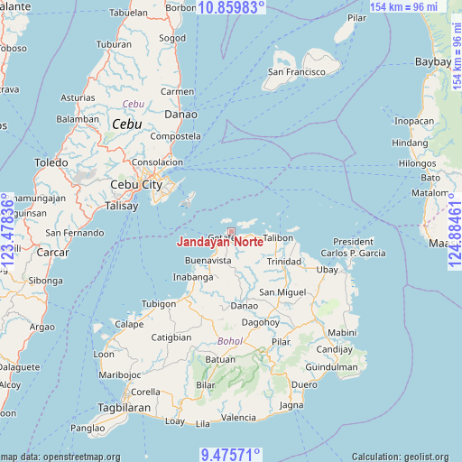
Jandayan Norte GPS coordinates[2]
10° 10' 6.672" North, 124° 10' 53.328" East
| Map corner | latitude | longitude |
|---|---|---|
| Upper-left | 10.85983°, | 123.47836° |
| Center: | 10.16852°, | 124.18148° |
| Lower-right: | 9.47571°, | 124.88461° |
| Map W x H: | 153.9×153.9 km | = 95.6×95.6mi |
| max Lat: | 20.78733° ⇑66.6% North |
| Jandayan Norte: | 10.16852° |
| min Lat: | ⇓33.4% South 4.65442° |
| min Long | Jandayan Norte | max Long |
| 117.04868° | 124.18148° | 126.58417° |
| W 73.8%⇐ | ⇒26.2% E |
Elevation
Elevation of Jandayan Norte is 8 m = 26 ft, and this is 79.9 m = 262 ft below average elevation for this country.
| Max E: |
2262 m = 7421 ft | 85.4% |
| Avg. | 87.9 m = 288 ft | |
| Jandayan Norte | 8 m = 26 ft | |
Min E: |
-2 m = -7 ft | 14.6% |
See also: Philippines elevation on elevation.city.
Geographical zone
Jandayan Norte is located in North Torrid zone (between Equator and Tropic of Cancer). Distance of Equator is 1130.6 km =702.5 mi to South.| Distance of | km | miles | from Jandayan Norte |
|---|---|---|---|
| North Pole | 8876.4 | 5515.5 | to North |
| Arctic Circle | 6270.5 | 3896.3 | to North |
| Tropic Cancer | 1475.3 | 916.7 | to North |
| Equator | 1130.6 | 702.5 | to South |


Nearby cities:
15 places around Jandayan Norte: (largest is in red/bold)
• Bagacay
8.6 km =5.3 mi,  102°
102°
• Bien Unido
21.7 km =13.5 mi, 99°
• Buenavista
11.9 km =7.4 mi,  217°
217°
• Cabul-an
15.1 km =9.4 mi,  265°
265°
• Calituban
14.5 km =9 mi,  56°
56°
• Danao
25.3 km =15.7 mi,  169°
169°
• Hinlayagan Ilaud
22.7 km =14.1 mi,  132°
132°
• Inabanga
19.8 km =12.3 mi, 219°
• Jetafe
3.8 km =2.4 mi,  231°
231°
• Nahawan
26.3 km =16.3 mi,  213°
213°
• San Francisco
14.2 km =8.8 mi,  93°
93°
• San Roque
17.6 km =10.9 mi,  118°
118°
• Tagum Norte
25 km =15.5 mi,  114°
114°
• Talibon
15.9 km =9.9 mi, 97°
• Trinidad
20.3 km =12.6 mi, 119°
Sources, notices
• [Note1] Compared only with cities in Philippines existing in our database
• [Src1] Map data: © OpenStreetMap contributors (CC-BY-SA)
• [Src2] Other city data from geonames.org with taken over terms of usage.
• [Src3] Geographical zone / Annual Mean Temperature by Robert A. Rohde @ Wikipedia
